Lot
Tucker Farm
Lot Group
Original Grants and Farms
Property Was Used in 1660 For:
Original Grants and Farms Document(s)
Grant Lot Document(s)
Tax Lot Events
Full Stokes Entry (See images below)
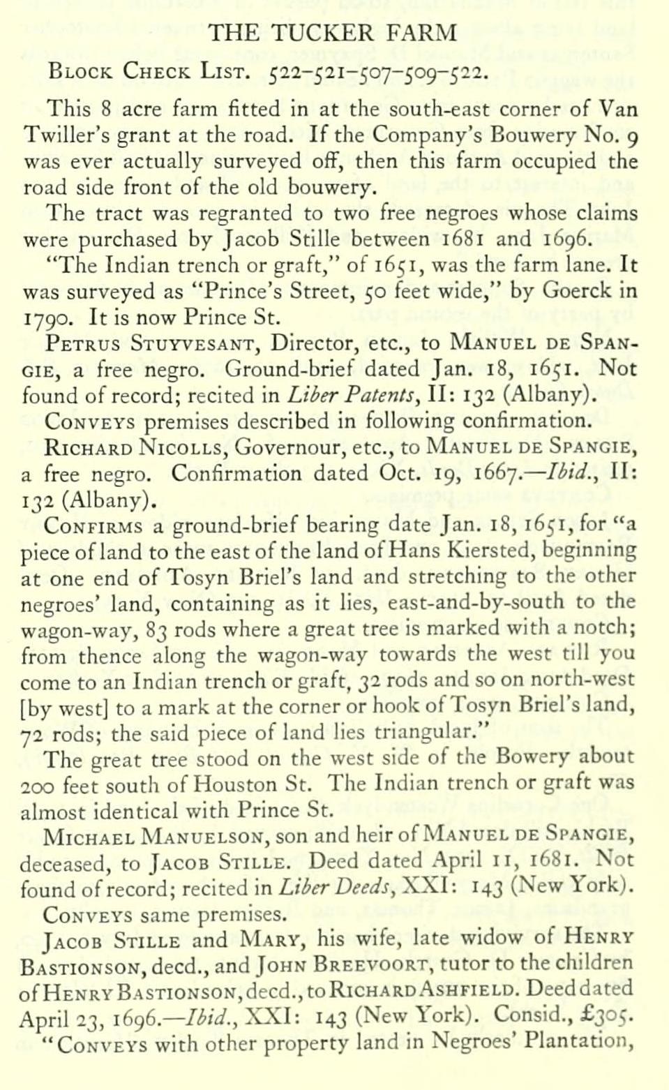
THE TUCKER FARM Block Check List. 522-521-507-509-522.
This 8 acre farm fitted in at the south-east corner of Van Twiller's grant at the road. If the Company's Bouwery No. 9 was ever actually surveyed ofF, then this farm occupied the road side front of the old bouwery.
The tract was regranted to two free negroes whose claims were purchased by Jacob Stille between 1681 and 1696.
"The Indian trench or graft," of 1651, was the farm lane. It was surveyed as "Prince's Street, 50 feet wide," by Goerck in 1790. It is now Prince St.
Petrus Stuyvesant, Director, etc., to Manuel de SpanGIE, a free negro. Ground-brief dated Jan. 18, 1651. Not found of record; recited in Liber Patents, II: 132 (Albany).
Conveys premises described in following confirmation.
Richard Nicolls, Governour, etc., to Manuel de Spangie, a free negro. Confirmation dated Oct. 19, 1667. — Ibid., II: 132 (Albany).
Confirms a ground-brief bearing date Jan. 18, 1651, for "a piece of land to the east of the land of Hans Kiersted, beginning at one end of Tosyn Briel's land and stretching to the other negroes' land, containing as it lies, east-and-by-south to the wagon-way, 83 rods where a great tree is marked with a notch; from thence along the wagon-w.ay towards the west till you come to an Indian trench or graft, 32 rods and so on north-west [by west] to a mark at the corner or hook of Tosyn Briel's land, 72 rods; the said piece of land lies triangular."
The great tree stood on the west side of the Bowery about 200 feet south of Houston St. The Indian trench or graft was almost identical with Prince St.
Michael Manuelson, son and heir of Manuel de Spangie, deceased, to Jacob Stille. Deed dated April 11, 1681. Not found of record; recited in Liber Deeds, XXI: 143 (New York).
Conveys same premises.
Jacob Stille and Mary, his wife, late widow of Henry Bastionson, deed., and John Breevoort, tutor to the children of Henry Bastionson, deed., to Richard.'\shfield. Deeddated April 23, i6g6.— Ibid., XXI: I43 (New York). Consid., £305.
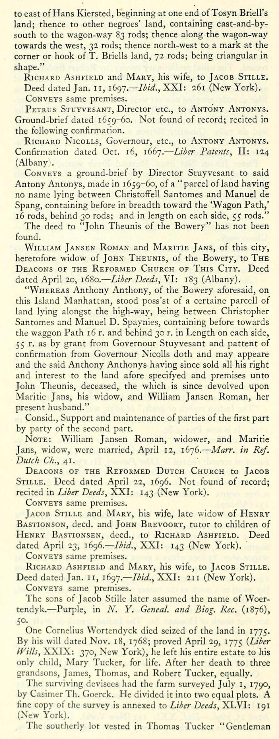
"Conveys with other property land in Negroes' Plantation, to east of Hans Kiersted, beginning atone end ofTosyn Briell's land; thence to other negroes' land, containing east-and-bysouth to the wagon-way 83 rods; thence along the wagon-way towards the west, 32 rods; thence north-west to a mark at the corner or hook of T. Briells land, 72 rods; being triangular in shape."
Richard Ashfield and Mary, his wife, to Jacob Stille.
Deed dated Jan. 11, 1697. — Ibid., XXI: 261 (New York).
Conveys same premises.
Petrus Stuyvesant, Director etc., to Antony Antonys. Ground-brief dated 1659-60. Not found of record; recited in the following confirmation.
Richard Nicolls, Governour, etc., to Antony Antonys. Confirmation dated Oct. 16, 1667. — Liber Patents, II: 124 (Albany).
Conveys a ground-brief by Director Stuyvesant to said Antony Antonys, made in 1659-60, of a "parcel of land having no name lying between ChristofFell Santomes and Manuel de Spang, containing before in breadth toward the 'Wagon Path,' 16 rods, behind 30 rods; and in length on each side, 55 rods."
The deed to "John Theunis of the Bowery" has not been found.
William Jansen Roman and Maritie Jans, of this city, heretofore widow of John Theunis, of the Bowery, to The Deacons of the Reformed Church of This City. Deed dated April 20, 1680. — Liber Deeds, VI: 183 (Albany).
"Whereas Anthony Anthony, of the Bowery aforesaid, on this Island Manhattan, stood poss'st of a certaine parcell of land lying alongst the high-way, being between Christopher Santomes and Manuel D. Spaynies, containing before towards the waggon Path 16 r. and behind 30 r. in Length on each side, 55 r. as by grant from Governour Stuyvesant and pattent of confirmation from Governour Nicolls doth and may appeare and the said Anthony Anthonys having since sold all his right and interest to the land afore specifyed and premises unto John Theunis, deceased, the which is since devolved upon Maritie Jans, his widow, and William Jansen Roman, her present husband."
Consid., Support and maintenance of parties of the first part by party of the second part.
Note: William Jansen Roman, widower, and Maritie Jans, widow, were married, April 12, 1676. — Marr. in Ref. Dutch Ch., 41.
Deacons of the Reformed Dutch Church to Jacob Stille. Deed dated April 22, 1696. Not found of record; recited in Liber Deeds, XXI: 143 (New York).
Conveys same premises.
Jacob Stille and Mary, his wife, late widow of Henry Bastionson, deed, and John Brevoort, tutor to children of Henry Bastionsen, deed., to Richard Ashfield. Deed dated April 23, i6<)6.—Ibid., XXI: 143 (New York).
Conveys same premises.
Richard Ashfield and Mary, his wife, to Jacob Stille. Deed dated Jan. 11, 1697. — Ibid., XXI: 211 (New York).
Conveys same premises.
The sons of Jacob Stille later assumed the name of Woertendyk. — Purple, in A''. Y. Geneal. and Biog. Rec. (1876),
50-,
One Cornelius Wortendyck died seized of the land in 1775. By his will dated Nov. 18, 1768; proved April 29, 1775 (Liber fFills, XXIX: 370, New York), he left his entire estate to his only child, Mary Tucker, for life. After her death to three grandsons, James, Thomas, and Robert Tucker, equally.
The surviving devisees had the farm surveyed July i, 1790, by Casimer Th. Goerck. He divided it into two equal plots. A fine copy of the survey is annexed to Liber Deeds, XLVI: 191 (New York).
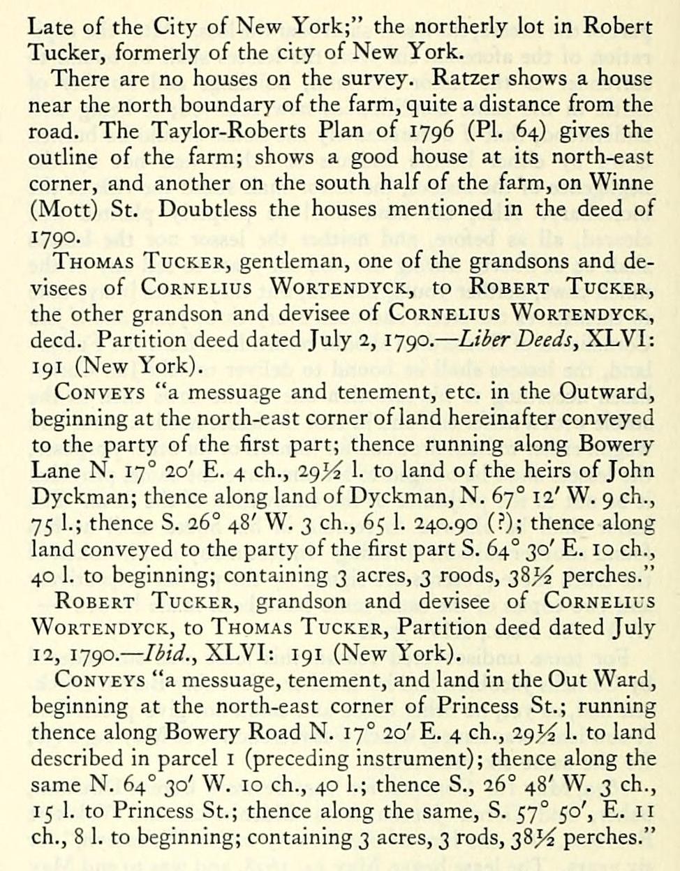
The southerly lot vested in Thomas Tucker "Gentleman
Late of the City of New York;" the northerly lot in Robert Tucker, formerly of the city of New York.
There are no houses on the survey. Ratzer shows a house near the north boundary of the farm, quite a distance from the road. The Taylor-Roberts Plan of 1796 (PI. 64) gives the outline of the farm; shows a good house at its north-east corner, and another on the south half of the farm, on Winne (Mott) St. Doubtless the houses mentioned in the deed of 1790.
Thomas Tucker, gentleman, one of the grandsons and devisees of Cornelius Wortendyck, to Robert Tucker, the other grandson and devisee of Cornelius Wortendyck, deed. Partition deed dated July 2, 1790. — Liber Deeds, XLVI: 191 (New York).
Conveys "a messuage and tenement, etc. in the Outward, beginning at the north-east corner of land hereinafter conveyed to the party of the first part; thence running along Bowery Lane N. 17° 20' E. 4 ch., 29^2 1. to land of the heirs of John Dyckman; thence along land of Dyckman, N. 67° 12' W. 9 ch., 75 1.; thence S. 26° 48' W. 3 ch., 65 1. 240.90 (?); thence along land conveyed to the party of the first part S. 64° 30' E. 10 ch., 40 1. to beginning; containing 3 acres, 3 roods, 38^^ perches."
Robert Tucker, grandson and devisee of Cornelius Wortendyck, to Thomas Tucker, Partition deed dated July 12, 1790. — Ibid., XLVI: 191 (New York).
Conveys "a messuage, tenement, and land in the Out Ward, beginning at the north-east corner of Princess St.; running thence along Bowery Road N. 17° 20' E. 4 ch., 29^ 1. to land described in parcel i (preceding instrument); thence along the same N. 64° 30' W. 10 ch., 40 1.; thence S., 26° 48' W. 3 ch., 15 1. to Princess St.; thence along the same, S. 57° 50', E. 11 ch., 8 1. to beginning; containing 3 acres, 3 rods, 38^ perches."
This 8 acre farm fitted in at the south-east corner of Van Twiller's grant at the road. If the Company's Bouwery No. 9 was ever actually surveyed ofF, then this farm occupied the road side front of the old bouwery.
The tract was regranted to two free negroes whose claims were purchased by Jacob Stille between 1681 and 1696.
"The Indian trench or graft," of 1651, was the farm lane. It was surveyed as "Prince's Street, 50 feet wide," by Goerck in 1790. It is now Prince St.
Petrus Stuyvesant, Director, etc., to Manuel de SpanGIE, a free negro. Ground-brief dated Jan. 18, 1651. Not found of record; recited in Liber Patents, II: 132 (Albany).
Conveys premises described in following confirmation.
Richard Nicolls, Governour, etc., to Manuel de Spangie, a free negro. Confirmation dated Oct. 19, 1667. — Ibid., II: 132 (Albany).
Confirms a ground-brief bearing date Jan. 18, 1651, for "a piece of land to the east of the land of Hans Kiersted, beginning at one end of Tosyn Briel's land and stretching to the other negroes' land, containing as it lies, east-and-by-south to the wagon-way, 83 rods where a great tree is marked with a notch; from thence along the wagon-w.ay towards the west till you come to an Indian trench or graft, 32 rods and so on north-west [by west] to a mark at the corner or hook of Tosyn Briel's land, 72 rods; the said piece of land lies triangular."
The great tree stood on the west side of the Bowery about 200 feet south of Houston St. The Indian trench or graft was almost identical with Prince St.
Michael Manuelson, son and heir of Manuel de Spangie, deceased, to Jacob Stille. Deed dated April 11, 1681. Not found of record; recited in Liber Deeds, XXI: 143 (New York).
Conveys same premises.
Jacob Stille and Mary, his wife, late widow of Henry Bastionson, deed., and John Breevoort, tutor to the children of Henry Bastionson, deed., to Richard.'\shfield. Deeddated April 23, i6g6.— Ibid., XXI: I43 (New York). Consid., £305.
"Conveys with other property land in Negroes' Plantation, to east of Hans Kiersted, beginning atone end ofTosyn Briell's land; thence to other negroes' land, containing east-and-bysouth to the wagon-way 83 rods; thence along the wagon-way towards the west, 32 rods; thence north-west to a mark at the corner or hook of T. Briells land, 72 rods; being triangular in shape."
Richard Ashfield and Mary, his wife, to Jacob Stille.
Deed dated Jan. 11, 1697. — Ibid., XXI: 261 (New York).
Conveys same premises.
Petrus Stuyvesant, Director etc., to Antony Antonys. Ground-brief dated 1659-60. Not found of record; recited in the following confirmation.
Richard Nicolls, Governour, etc., to Antony Antonys. Confirmation dated Oct. 16, 1667. — Liber Patents, II: 124 (Albany).
Conveys a ground-brief by Director Stuyvesant to said Antony Antonys, made in 1659-60, of a "parcel of land having no name lying between ChristofFell Santomes and Manuel de Spang, containing before in breadth toward the 'Wagon Path,' 16 rods, behind 30 rods; and in length on each side, 55 rods."
The deed to "John Theunis of the Bowery" has not been found.
William Jansen Roman and Maritie Jans, of this city, heretofore widow of John Theunis, of the Bowery, to The Deacons of the Reformed Church of This City. Deed dated April 20, 1680. — Liber Deeds, VI: 183 (Albany).
"Whereas Anthony Anthony, of the Bowery aforesaid, on this Island Manhattan, stood poss'st of a certaine parcell of land lying alongst the high-way, being between Christopher Santomes and Manuel D. Spaynies, containing before towards the waggon Path 16 r. and behind 30 r. in Length on each side, 55 r. as by grant from Governour Stuyvesant and pattent of confirmation from Governour Nicolls doth and may appeare and the said Anthony Anthonys having since sold all his right and interest to the land afore specifyed and premises unto John Theunis, deceased, the which is since devolved upon Maritie Jans, his widow, and William Jansen Roman, her present husband."
Consid., Support and maintenance of parties of the first part by party of the second part.
Note: William Jansen Roman, widower, and Maritie Jans, widow, were married, April 12, 1676. — Marr. in Ref. Dutch Ch., 41.
Deacons of the Reformed Dutch Church to Jacob Stille. Deed dated April 22, 1696. Not found of record; recited in Liber Deeds, XXI: 143 (New York).
Conveys same premises.
Jacob Stille and Mary, his wife, late widow of Henry Bastionson, deed, and John Brevoort, tutor to children of Henry Bastionsen, deed., to Richard Ashfield. Deed dated April 23, i6<)6.—Ibid., XXI: 143 (New York).
Conveys same premises.
Richard Ashfield and Mary, his wife, to Jacob Stille. Deed dated Jan. 11, 1697. — Ibid., XXI: 211 (New York).
Conveys same premises.
The sons of Jacob Stille later assumed the name of Woertendyk. — Purple, in A''. Y. Geneal. and Biog. Rec. (1876),
50-,
One Cornelius Wortendyck died seized of the land in 1775. By his will dated Nov. 18, 1768; proved April 29, 1775 (Liber fFills, XXIX: 370, New York), he left his entire estate to his only child, Mary Tucker, for life. After her death to three grandsons, James, Thomas, and Robert Tucker, equally.
The surviving devisees had the farm surveyed July i, 1790, by Casimer Th. Goerck. He divided it into two equal plots. A fine copy of the survey is annexed to Liber Deeds, XLVI: 191 (New York).
The southerly lot vested in Thomas Tucker "Gentleman
Late of the City of New York;" the northerly lot in Robert Tucker, formerly of the city of New York.
There are no houses on the survey. Ratzer shows a house near the north boundary of the farm, quite a distance from the road. The Taylor-Roberts Plan of 1796 (PI. 64) gives the outline of the farm; shows a good house at its north-east corner, and another on the south half of the farm, on Winne (Mott) St. Doubtless the houses mentioned in the deed of 1790.
Thomas Tucker, gentleman, one of the grandsons and devisees of Cornelius Wortendyck, to Robert Tucker, the other grandson and devisee of Cornelius Wortendyck, deed. Partition deed dated July 2, 1790. — Liber Deeds, XLVI: 191 (New York).
Conveys "a messuage and tenement, etc. in the Outward, beginning at the north-east corner of land hereinafter conveyed to the party of the first part; thence running along Bowery Lane N. 17° 20' E. 4 ch., 29^2 1. to land of the heirs of John Dyckman; thence along land of Dyckman, N. 67° 12' W. 9 ch., 75 1.; thence S. 26° 48' W. 3 ch., 65 1. 240.90 (?); thence along land conveyed to the party of the first part S. 64° 30' E. 10 ch., 40 1. to beginning; containing 3 acres, 3 roods, 38^^ perches."
Robert Tucker, grandson and devisee of Cornelius Wortendyck, to Thomas Tucker, Partition deed dated July 12, 1790. — Ibid., XLVI: 191 (New York).
Conveys "a messuage, tenement, and land in the Out Ward, beginning at the north-east corner of Princess St.; running thence along Bowery Road N. 17° 20' E. 4 ch., 29^ 1. to land described in parcel i (preceding instrument); thence along the same N. 64° 30' W. 10 ch., 40 1.; thence S., 26° 48' W. 3 ch., 15 1. to Princess St.; thence along the same, S. 57° 50', E. 11 ch., 8 1. to beginning; containing 3 acres, 3 rods, 38^ perches."