Lot
Robert Richard Randall Farm
Lot Group
Original Grants and Farms
Property Was Used in 1660 For:
Original Grants and Farms Document(s)
Grant Lot Document(s)
Tax Lot Events
Full Stokes Entry (See images below)
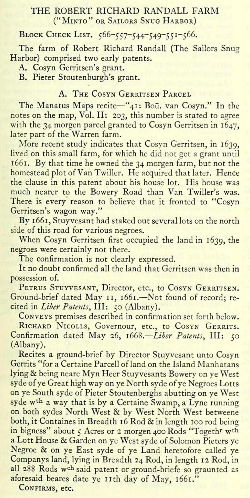
THE ROBERT RICHARD RANDALL FARM
("MiNTo" OR Sailors Snug Harbor)
Block Check List. 566-557-544-549-551-566.
The farm of Robert Richard Randall (The Sailors Snug Harbor) comprised two early patents.
A. Cosyn Gerritsen's grant.
B. Pieter Stoutenburgh's grant.
A. The Cosyn Gerritsen Parcel
The Manatus Maps recite — "41: Bo5. van Cosyn." In the notes on the map. Vol. II: 203, this number is stated to agree with the 34 morgen parcel granted to Cosyn Gerritsen in 1647, later part of the Warren farm.
More recent study indicates that Cosyn Gerritsen, in 1639, lived on this small farm, for which he did not get a grant until 1 66 1. By that time he owned the 34 morgen farm, but not the homestead plot of Van Twiller. He acquired that later. Hence the clause in this patent about his house lot. His house was much nearer to the Bowery Road than Van Twiller's was. There is every reason to believe that it fronted to "Cosyn Gerritsen's wagon way."
By 1661, Stuyvesant had staked out several lots on the north side of this road for various negroes.
When Cosyn Gerritsen first occupied the land in 1639, the negroes were certainly not there.
The confirmation is not clearly expressed.
It no doubt confirmed all the land that Gerritsen was then in possession of.
Petrus Stuyvesant, Director, etc., to Cosyn Gerritsen. Ground-brief dated May II, 1661. — Not found of record; recited in Liber Palenls, III: 50 (Albany).
Conveys premises described in confirmation set forth below.
Richard Nicolls, Governour, etc., to Cosyn Gerrits. Confirmation dated May 26, 1668. — Liber Patents, III: 50 (Albany).
Recites a ground-brief by Director Stuyvesant unto Cosyn Gerrits "for a Certaine Parcell of land on the Island Manhatans lying & being neare Myn Heer Stuyvesants Bowery on ye West syde of ye Great high way on ye North syde of ye Negroes Lotts on ye South syde of Pieter Stoutenberghs abutting on ye West syde wtli a way that is by a Certaine Swamp, a Lyne running on both sydes North West 8: by West North West betweene both, it Containes in Breadth 16 Rod & in length 100 rod being in bigness" about 5 Acres or 2 morgen 400 Rods "Togeth' w'li a Lott House & Garden on ye West syde of Solomon Pieters ye Negroe & on ye East syde of ye Land heretofore called ye Companys land, lying in Breadth 24 Rod, in length 12 Rod, in all 288 Rods w<:l> said patent or ground-briefe so graunted as aforesaid beares date ye nth day of May, 1661."
Confirms, etc.
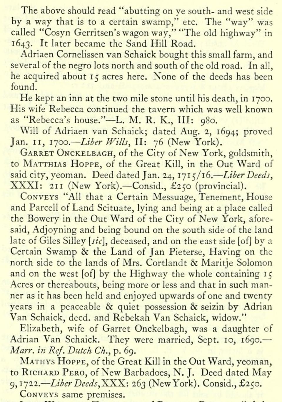
The above should read "abutting on ye south- and west side by a way that is to a certain swamp," etc. The "way" was called "Cosyn Gerritsen's wagon way," "The old highway" in 1643. It later became the Sand Hill Road.
Adriaen Cornelissen van Schaick bought this small farm, and several of the negro lots north and south of the old road. In all, he acquired about 15 acres here. None of the deeds has been found.
He kept an inn at the two mile stone until his death, in 1700. His wife Rebecca continued the tavern which was well known as "Rebecca's house." — L. M. R. K., Ill: 980.
Will of Adriaen van Schaick; dated Aug. 2, 1694; proved Jan. II, 1700. — Liber IVilts, II: 76 (New York).
Garret Onckelbagh, of the City of New York, goldsmith, to Matthias Hoppe, of the Great Kill, in the Out Ward of said city, yeoman. Deed dated Jan. 24, 1 71 5/1 6. — Liber Deeds, XXXI: 211 (New York). — Consid., £250 (provincial).
Conveys "All that a Certain Messuage, Tenement, House and Parcell of Land Scituate, lying and being at a place called the Bowery in the Out Ward of the City of New York, aforesaid, Adjoyning and being bound on the south side of the land late of Giles Silley [sic], deceased, and on the east side [of| by a Certain Swamp & the Land of Jan Pieterse, Having on the north side to the lands of Mrs. Cortlandt & Maritje Solomon and on the west [of] by the Highv/ay the whole containing 15 Acres or thereabouts, being more or less and that in such manner as it has been held and enjoyed upwards of one and twenty years in a peaceable & quiet possession & seizin by Adrian Van Schaick, deed, and Rebekah Van Schaick, widow."
Elizabeth, wife of Garret Onckelbagh, was a daughter of Adrian Van Schaick. They were married, Sept. 10, 1690. — • Marr. in Ref. Dutch Ch., p. 69.
Mathys Hoppe, of the Great Kill in the Out Ward, yeoman, to Richard Pero, of New Barbadoes, N. J. Deed dated May 9,1722. — Liber Deeds, XXX: 263 (New York). Consid., £250.
Conveys same premises.
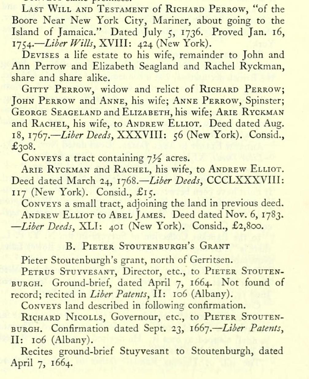
Last Will and Testament of Richard Perrow, "of the Boore Near New York City, Mariner, about going to the Island of Jamaica." Dated July 5, 1736. Proved Jan. 16, 1-JSA-— Liber Wills, XVIII: 424 (New York).
Devises a life estate to his wife, remainder to John and Ann Perrow and Elizabeth Seagland and Rachel Ryckman, share and share alike.
GiTTY Perrow, widow and relict of Richard Perrow; John Perrow and Anne, his wife; Anne Perrow, Spinster; George Seageland and Elizabeth, his wife; Arie Ryckman and Rachel, his wife, to Andrew Elliot. Deed dated Aug. \%,\']b-].— Liber Deeds, ^^XSSIW: 56 (New York). Consid., £308.
Conveys a tract containing -jyi acres.
Arie Ryckman and Rachel, his wife, to Andrew Elliot. Deed dated March 24, i-jS^.— Liber Deeds, CCCLXXXVIII: 117 (New York). Consid., £15.
Conveys a small tract, adjoining the land in previous deed.
Andrew Elliot to Abel James. Deed dated Nov. 6, 1783. — Liber Deeds, 'XLl: 401 (New York). Consid., £2,800.
B. Pieter Stoutenburgh's Grant
Pieter Stoutenburgh's grant, north of Gerritsen.
Petrus Stuyvesant, Director, etc., to Pieter Stoutenburgh. Ground-brief, dated April 7, 1664. Not found of record; recited in Liber Patents, II: 106 (Albany).
Conveys land described in following confirmation.
Richard Nicolls, Governour, etc., to Pieter Stoutenburgh. Confirmation dated Sept. 23, 1667. — Liber Patents, II: 106 (Albany).
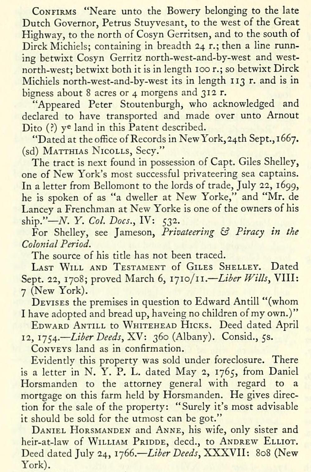
Recites ground-brief Stuyvesant to Stoutenburgh, dated April 7, 1664. Confirms "Neare unto the Bowery belonging to the late Dutch Governor, Petrus Stuyvesant, to the west of the Great Highway, to the north of Cosyn Gerritsen, and to the south of Dirck Michiels; containing in breadth 24 r.;then a line running betwixt Cosyn Gerritz north-west-and-by-west and westnorth-west; betwixt both it is in length 100 r.; so betwixt Dirck Michiels north-west-and-by-west its in length 113 r. and is in bigness about 8 acres or 4 morgens and 312 r.
"Appeared Peter Stoutenburgh, who acknowledged and declared to have transported and made over unto Arnout Dito (?) y^ land in this Patent described.
"Dated at the office of Records in New York, 24th Sept., 1667. (sd) Matthias Nicolls, Secy."
The tract is next found in possession of Capt. Giles Shelley, one of New York's most successful privateering sea captains. In a letter from Bellomont to the lords of trade, July 22, 1699, he is spoken of as "a dweller at New Yorke," and "Mr. de Lancey a Frenchman at New Yorke is one of the owners of his ship."— iV. y. Col. Docs., IV: 532.
For Shelley, see Jameson, Privateering & Piracy in the Colonial Period.
The source of his title has not been traced.
Last Will and Testament of Giles Shelley. Dated Sept. 22, 1708; proved March 6, 1710/11. — Liber Wills, VIII: 7 (New York).
Devises the premises in question to Edward Antill "(whom I have adopted and bread up, haveing no children of my own.)"
Edward Antill to Whitehead Hicks. Deed dated April 12,1754. — Liber Deeds, 'Sy-. 360 (Albany). Consid., 5s.
Conveys land as in confirmation.
Evidently this property was sold under foreclosure. There is a letter in N. Y. P. L. dated May 2, 1765, from Daniel Horsmanden to the attorney general with regard to a mortgage on this farm held by Horsmanden. He gives direction for the sale of the property: "Surely it's most advisable it should be sold for the utmost can be got."
Daniel Horsmanden and Anne, his wife, only sister and heir-at-law of William Pridde, deed., to Andrew Elliot. Deed dated July 24, !■](>(,.— Liber Deeds, XXXVII: 808 (New York).
Conveys same premises.
Andrew Elliot, who was made Lieut. Gov. of N. Y. during the British occupation, was a connection of the Earl of Minto. During the war he was noted for his kindness to American military prisoners. After the evacuation he returned to England. As an evidence of the esteem in which he was held, his property in New York was not confiscated. — Wilson, Memorial Hist, of the City of N.Y.,\l: 572.
Andrew Elliot to Abel James. Deed dated Nov. 6, 1783. — Liber Deeds, XLl: 401 (Slew York). Cons. £2,800.
Conveys, in several parcels, the farm called "Minto."
Minto was sold to Baron Poelnitz. Nothing of record. It must have been between Feb. 13, 1786, when Poelnitz occupied Petersfield house, and May 20, 1789, when Washington visited the farm to see Baron Poelnitz's experiments in agriculture.— Chronology.
In the Bancker Collection of Surveys in the N. Y. P. L., there is "A Draught of Andrew Eliot's Seat in the Bowry Lane, November i, 1783."
Frederick Charles Hans Poelnitz, commonly called Baron Poelnitz, to Robert R. Randall. Deed dated June 15, 1790. — Liber Deeds, XLVI: 212 (New York).
Conveys these and other premises.
Robert R. Randall either bought this property as agent for his father, or he sold it to him by a deed not of record. Thomas Randall claimed to own it. He devised it to his son Robert Richard Randall in his will.
The will of Thomas Randall father of Robert Richard
Randell, dated March 6, 1797, proved Dec. 4, 1797 (Liier JVills, XLII: 278, New York), after providing for his widow, Gertrude Randall, divides the estate between his three children, Robert Richard Randall, Paul R., and Catharine Randall. It contains this clause
"Item: I give, devise and bequeath unto my son, Robert R. Randall, all that certain farm or parcel of land situate in the Seventh Ward of the City of New York commonly called Minto, whereon he now lives, ... to have and to hold unto him and his heirs and assigns forever."
Robert Richard Randall did not long survive his father. He never married.
His will dated June I, 1801, proved July 14, 1801 {Liber Wills,yihlll; 440, New York), contains this residuary clause: "As to . . . all the rest, residue and remainder of my estate, both real and personal, I give devise and bequeath the same unto the Chancellor of the State of New York, the Mayor and Recorder of the City of New York, the President of the Chamber of Commerce in the City of New York, The President and Vice President of the Marine Society of the City of New York, the Senior Minister of the Episcopal Church in said City, and the Senior Minister of the Presbyterian Church in the said City ... to erect and build upon some eligible part of the land upon which I now reside, an asylum or Marine Hospital to be called 'The Sailor's Snug Harbor' for the purpose of maintaining and supporting aged, and decrepit and worn out sailors as soon as they my said Charity Trustees or a majority of them shall judge the proceeds of the said estate will support fifty of the said sailors and upwards. They to apply for an act of the Legislature to incorporate them for the purpose above specified."
An act was passed Feb. 6, 1806, Chap. IV: Laws 1806. Amended by Chap. LXIX: Laws 1814: Chap. CCLXXVI: Laws 1828, and Chap. CLIII: Laws 1834.
In a booklet published by the trustees of the Sailors Snug Harbor, several copies of which are in the N. Y. P. L., it is recited that "The apparent delay to carry into effect the design of the donor was occasioned in the first instance by the very limited income of the estate, and subsequently by the great expense necessarily incurred in defending suits brought against the Trustees by difi^erent claimants for the property and by heavy assessments in opening and regulating the streets," etc.
"It was not until March 1830 that the last suit brought against the Trustees by persons claiming to be heirs of Mr. Randall was finally and forever settled by the Supreme Court of the United States."
In May, 1831, the trustees bought a farm of 130 acres of land on Staten Island. This was later increased to 150 acres. The corner-stone of the first building was laid, Oct. 11, 1831. The house on Minto is shown on the Ratzer Map. See L. M. R. K., Ill: 95I-
("MiNTo" OR Sailors Snug Harbor)
Block Check List. 566-557-544-549-551-566.
The farm of Robert Richard Randall (The Sailors Snug Harbor) comprised two early patents.
A. Cosyn Gerritsen's grant.
B. Pieter Stoutenburgh's grant.
A. The Cosyn Gerritsen Parcel
The Manatus Maps recite — "41: Bo5. van Cosyn." In the notes on the map. Vol. II: 203, this number is stated to agree with the 34 morgen parcel granted to Cosyn Gerritsen in 1647, later part of the Warren farm.
More recent study indicates that Cosyn Gerritsen, in 1639, lived on this small farm, for which he did not get a grant until 1 66 1. By that time he owned the 34 morgen farm, but not the homestead plot of Van Twiller. He acquired that later. Hence the clause in this patent about his house lot. His house was much nearer to the Bowery Road than Van Twiller's was. There is every reason to believe that it fronted to "Cosyn Gerritsen's wagon way."
By 1661, Stuyvesant had staked out several lots on the north side of this road for various negroes.
When Cosyn Gerritsen first occupied the land in 1639, the negroes were certainly not there.
The confirmation is not clearly expressed.
It no doubt confirmed all the land that Gerritsen was then in possession of.
Petrus Stuyvesant, Director, etc., to Cosyn Gerritsen. Ground-brief dated May II, 1661. — Not found of record; recited in Liber Palenls, III: 50 (Albany).
Conveys premises described in confirmation set forth below.
Richard Nicolls, Governour, etc., to Cosyn Gerrits. Confirmation dated May 26, 1668. — Liber Patents, III: 50 (Albany).
Recites a ground-brief by Director Stuyvesant unto Cosyn Gerrits "for a Certaine Parcell of land on the Island Manhatans lying & being neare Myn Heer Stuyvesants Bowery on ye West syde of ye Great high way on ye North syde of ye Negroes Lotts on ye South syde of Pieter Stoutenberghs abutting on ye West syde wtli a way that is by a Certaine Swamp, a Lyne running on both sydes North West 8: by West North West betweene both, it Containes in Breadth 16 Rod & in length 100 rod being in bigness" about 5 Acres or 2 morgen 400 Rods "Togeth' w'li a Lott House & Garden on ye West syde of Solomon Pieters ye Negroe & on ye East syde of ye Land heretofore called ye Companys land, lying in Breadth 24 Rod, in length 12 Rod, in all 288 Rods w<:l> said patent or ground-briefe so graunted as aforesaid beares date ye nth day of May, 1661."
Confirms, etc.
The above should read "abutting on ye south- and west side by a way that is to a certain swamp," etc. The "way" was called "Cosyn Gerritsen's wagon way," "The old highway" in 1643. It later became the Sand Hill Road.
Adriaen Cornelissen van Schaick bought this small farm, and several of the negro lots north and south of the old road. In all, he acquired about 15 acres here. None of the deeds has been found.
He kept an inn at the two mile stone until his death, in 1700. His wife Rebecca continued the tavern which was well known as "Rebecca's house." — L. M. R. K., Ill: 980.
Will of Adriaen van Schaick; dated Aug. 2, 1694; proved Jan. II, 1700. — Liber IVilts, II: 76 (New York).
Garret Onckelbagh, of the City of New York, goldsmith, to Matthias Hoppe, of the Great Kill, in the Out Ward of said city, yeoman. Deed dated Jan. 24, 1 71 5/1 6. — Liber Deeds, XXXI: 211 (New York). — Consid., £250 (provincial).
Conveys "All that a Certain Messuage, Tenement, House and Parcell of Land Scituate, lying and being at a place called the Bowery in the Out Ward of the City of New York, aforesaid, Adjoyning and being bound on the south side of the land late of Giles Silley [sic], deceased, and on the east side [of| by a Certain Swamp & the Land of Jan Pieterse, Having on the north side to the lands of Mrs. Cortlandt & Maritje Solomon and on the west [of] by the Highv/ay the whole containing 15 Acres or thereabouts, being more or less and that in such manner as it has been held and enjoyed upwards of one and twenty years in a peaceable & quiet possession & seizin by Adrian Van Schaick, deed, and Rebekah Van Schaick, widow."
Elizabeth, wife of Garret Onckelbagh, was a daughter of Adrian Van Schaick. They were married, Sept. 10, 1690. — • Marr. in Ref. Dutch Ch., p. 69.
Mathys Hoppe, of the Great Kill in the Out Ward, yeoman, to Richard Pero, of New Barbadoes, N. J. Deed dated May 9,1722. — Liber Deeds, XXX: 263 (New York). Consid., £250.
Conveys same premises.
Last Will and Testament of Richard Perrow, "of the Boore Near New York City, Mariner, about going to the Island of Jamaica." Dated July 5, 1736. Proved Jan. 16, 1-JSA-— Liber Wills, XVIII: 424 (New York).
Devises a life estate to his wife, remainder to John and Ann Perrow and Elizabeth Seagland and Rachel Ryckman, share and share alike.
GiTTY Perrow, widow and relict of Richard Perrow; John Perrow and Anne, his wife; Anne Perrow, Spinster; George Seageland and Elizabeth, his wife; Arie Ryckman and Rachel, his wife, to Andrew Elliot. Deed dated Aug. \%,\']b-].— Liber Deeds, ^^XSSIW: 56 (New York). Consid., £308.
Conveys a tract containing -jyi acres.
Arie Ryckman and Rachel, his wife, to Andrew Elliot. Deed dated March 24, i-jS^.— Liber Deeds, CCCLXXXVIII: 117 (New York). Consid., £15.
Conveys a small tract, adjoining the land in previous deed.
Andrew Elliot to Abel James. Deed dated Nov. 6, 1783. — Liber Deeds, 'XLl: 401 (New York). Consid., £2,800.
B. Pieter Stoutenburgh's Grant
Pieter Stoutenburgh's grant, north of Gerritsen.
Petrus Stuyvesant, Director, etc., to Pieter Stoutenburgh. Ground-brief, dated April 7, 1664. Not found of record; recited in Liber Patents, II: 106 (Albany).
Conveys land described in following confirmation.
Richard Nicolls, Governour, etc., to Pieter Stoutenburgh. Confirmation dated Sept. 23, 1667. — Liber Patents, II: 106 (Albany).
Recites ground-brief Stuyvesant to Stoutenburgh, dated April 7, 1664. Confirms "Neare unto the Bowery belonging to the late Dutch Governor, Petrus Stuyvesant, to the west of the Great Highway, to the north of Cosyn Gerritsen, and to the south of Dirck Michiels; containing in breadth 24 r.;then a line running betwixt Cosyn Gerritz north-west-and-by-west and westnorth-west; betwixt both it is in length 100 r.; so betwixt Dirck Michiels north-west-and-by-west its in length 113 r. and is in bigness about 8 acres or 4 morgens and 312 r.
"Appeared Peter Stoutenburgh, who acknowledged and declared to have transported and made over unto Arnout Dito (?) y^ land in this Patent described.
"Dated at the office of Records in New York, 24th Sept., 1667. (sd) Matthias Nicolls, Secy."
The tract is next found in possession of Capt. Giles Shelley, one of New York's most successful privateering sea captains. In a letter from Bellomont to the lords of trade, July 22, 1699, he is spoken of as "a dweller at New Yorke," and "Mr. de Lancey a Frenchman at New Yorke is one of the owners of his ship."— iV. y. Col. Docs., IV: 532.
For Shelley, see Jameson, Privateering & Piracy in the Colonial Period.
The source of his title has not been traced.
Last Will and Testament of Giles Shelley. Dated Sept. 22, 1708; proved March 6, 1710/11. — Liber Wills, VIII: 7 (New York).
Devises the premises in question to Edward Antill "(whom I have adopted and bread up, haveing no children of my own.)"
Edward Antill to Whitehead Hicks. Deed dated April 12,1754. — Liber Deeds, 'Sy-. 360 (Albany). Consid., 5s.
Conveys land as in confirmation.
Evidently this property was sold under foreclosure. There is a letter in N. Y. P. L. dated May 2, 1765, from Daniel Horsmanden to the attorney general with regard to a mortgage on this farm held by Horsmanden. He gives direction for the sale of the property: "Surely it's most advisable it should be sold for the utmost can be got."
Daniel Horsmanden and Anne, his wife, only sister and heir-at-law of William Pridde, deed., to Andrew Elliot. Deed dated July 24, !■](>(,.— Liber Deeds, XXXVII: 808 (New York).
Conveys same premises.
Andrew Elliot, who was made Lieut. Gov. of N. Y. during the British occupation, was a connection of the Earl of Minto. During the war he was noted for his kindness to American military prisoners. After the evacuation he returned to England. As an evidence of the esteem in which he was held, his property in New York was not confiscated. — Wilson, Memorial Hist, of the City of N.Y.,\l: 572.
Andrew Elliot to Abel James. Deed dated Nov. 6, 1783. — Liber Deeds, XLl: 401 (Slew York). Cons. £2,800.
Conveys, in several parcels, the farm called "Minto."
Minto was sold to Baron Poelnitz. Nothing of record. It must have been between Feb. 13, 1786, when Poelnitz occupied Petersfield house, and May 20, 1789, when Washington visited the farm to see Baron Poelnitz's experiments in agriculture.— Chronology.
In the Bancker Collection of Surveys in the N. Y. P. L., there is "A Draught of Andrew Eliot's Seat in the Bowry Lane, November i, 1783."
Frederick Charles Hans Poelnitz, commonly called Baron Poelnitz, to Robert R. Randall. Deed dated June 15, 1790. — Liber Deeds, XLVI: 212 (New York).
Conveys these and other premises.
Robert R. Randall either bought this property as agent for his father, or he sold it to him by a deed not of record. Thomas Randall claimed to own it. He devised it to his son Robert Richard Randall in his will.
The will of Thomas Randall father of Robert Richard
Randell, dated March 6, 1797, proved Dec. 4, 1797 (Liier JVills, XLII: 278, New York), after providing for his widow, Gertrude Randall, divides the estate between his three children, Robert Richard Randall, Paul R., and Catharine Randall. It contains this clause
"Item: I give, devise and bequeath unto my son, Robert R. Randall, all that certain farm or parcel of land situate in the Seventh Ward of the City of New York commonly called Minto, whereon he now lives, ... to have and to hold unto him and his heirs and assigns forever."
Robert Richard Randall did not long survive his father. He never married.
His will dated June I, 1801, proved July 14, 1801 {Liber Wills,yihlll; 440, New York), contains this residuary clause: "As to . . . all the rest, residue and remainder of my estate, both real and personal, I give devise and bequeath the same unto the Chancellor of the State of New York, the Mayor and Recorder of the City of New York, the President of the Chamber of Commerce in the City of New York, The President and Vice President of the Marine Society of the City of New York, the Senior Minister of the Episcopal Church in said City, and the Senior Minister of the Presbyterian Church in the said City ... to erect and build upon some eligible part of the land upon which I now reside, an asylum or Marine Hospital to be called 'The Sailor's Snug Harbor' for the purpose of maintaining and supporting aged, and decrepit and worn out sailors as soon as they my said Charity Trustees or a majority of them shall judge the proceeds of the said estate will support fifty of the said sailors and upwards. They to apply for an act of the Legislature to incorporate them for the purpose above specified."
An act was passed Feb. 6, 1806, Chap. IV: Laws 1806. Amended by Chap. LXIX: Laws 1814: Chap. CCLXXVI: Laws 1828, and Chap. CLIII: Laws 1834.
In a booklet published by the trustees of the Sailors Snug Harbor, several copies of which are in the N. Y. P. L., it is recited that "The apparent delay to carry into effect the design of the donor was occasioned in the first instance by the very limited income of the estate, and subsequently by the great expense necessarily incurred in defending suits brought against the Trustees by difi^erent claimants for the property and by heavy assessments in opening and regulating the streets," etc.
"It was not until March 1830 that the last suit brought against the Trustees by persons claiming to be heirs of Mr. Randall was finally and forever settled by the Supreme Court of the United States."
In May, 1831, the trustees bought a farm of 130 acres of land on Staten Island. This was later increased to 150 acres. The corner-stone of the first building was laid, Oct. 11, 1831. The house on Minto is shown on the Ratzer Map. See L. M. R. K., Ill: 95I-