Lot
Rem Rapelje Farm
Lot Group
Original Grants and Farms
Property Was Used in 1660 For:
Original Grants and Farms Document(s)
Grant Lot Document(s)
Tax Lot Events
Full Stokes Entry (See images below)
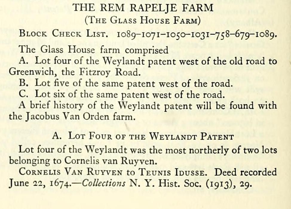
THE REM RAPELJE FARM (The Glass House Farm)
Block Check List. 1089-1071-1050-1031-758-679-1089.
The Glass House farm comprised
A. Lot four of the Weylandt patent west of the old road to Greenwich, the Fitzroy Road.
B. Lot five of the same patent west of the road.
C. Lot six of the same patent west of the road.
A brief history of the Weylandt patent will be found with the Jacobus Van Orden farm.
A. Lot Four of the Weylandt Patent Lot four of the Weylandt was the most northerly of two lots
belonging to Cornells van Ruyven.
CoRNELis Van Ruyven to Teunis Idusse. Deed recorded
June 22, 1674. — Collections N. Y. Hist. Soc. (1913), 29.
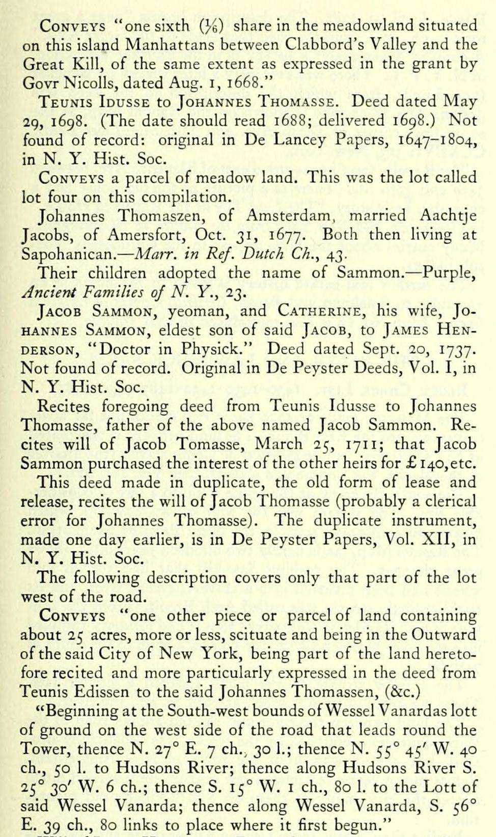
Conveys "one sixth (J-e) share in the meadowland situated on this island Manhattans between Clabbord's Valley and the Great Kill, of the same extent as expressed in the grant by Govr Nicolls, dated Aug. i, 1668."
Teunis Idusse to Johannes Thomasse. Deed dated May 2g, 1698. (The date should read 1688; delivered i6g8.) Not found of record: original in De Lancey Papers, 1647-1804, in N. Y. Hist. Soc.
Conveys a parcel of meadow land. This was the lot called lot four on this compilation.
Johannes Thomaszen, of Amsterdam, married Aachtje Jacobs, of Amersfort, Oct. 31, 1677. Both then living at Sapohanican. — Mair. in Ref. Dutch Ch., 43.
Their children adopted the name of Sammon. — Purple, Ancient Families of N. Y., 23.
Jacob Sammon, yeoman, and Catherine, his wife, Johannes Sammon, eldest son of said Jacob, to James Henderson, "Doctor in Physick." Deed dated Sept. 20, 1737. Not found of record. Original in De Peyster Deeds, Vol. I, in N. Y. Hist. Soc.
Recites foregoing deed from Teunis Idusse to Johannes Thomasse, father of the above named Jacob Sammon. Recites will of Jacob Tomasse, March 25, 171 1; that Jacob Sammon purchased the interest of the other heirs for £ I40,etc.
This deed made in duplicate, the old form of lease and release, recites the will of Jacob Thomasse (probably a clerical error for Johannes Thomasse). The duplicate instrument, made one day earlier, is in De Peyster Papers, Vol. XII, in N. Y. Hist. Soc.
The following description covers only that part of the lot west of the road.
Conveys "one other piece or parcel of land containing about 25 acres, more or less, scituate and being in the Outward of the said City of New York, being part of the land heretofore recited and more particularly expressed in the deed from Teunis Edissen to the said Johannes Thomassen, (&c.)
"Beginning at the South-west bounds of Wessel Vanardas lott of ground on the west side of the road that leads round the Tower, thence N. 27° E. 7 ch., 30 1.; thence N. 55° 45' W. 40 ch., 50 1. to Hudsons River; thence along Hudsons River S. 25° 30' W. 6 ch.; thence S. 15° W. I ch., 80 1. to the Lott of said Wessel Vanarda; thence along Wessel Vanarda, S. 56° E. 39 ch., 80 links to place where it first begun."
Will of James Henderson. Dated Oct. 7, 1743; proved Dec. l6, 1743. — Li/>er JVitls, XV: 150 (New York).
TiESSE Henderson and Margaret Henderson, Executrices of James Henderson, deed., to Peter Warren, Esq. Deed dated Sept. 25, 1744. Not found of record. Original in Warren Deeds, 1691-1784, in N. Y. Hist. Soc.
Conveys same as preceding deed.
WiLLOUGHBY, Earl of Abingdon, by his attorney and trustee, John Watts, to Rem Rapelye. Deeds of lease and release dated March 24-25, 1789. — Liber Deeds, CCLIX: 422, 451-60 (New York).
The Earl of Abingdon had married a daughter of Sir Peter Warren.
B. Lot Five of the Weylandt Patent
The most southerly lot patented to Paulus Leendertsen van der Grift.
Jacob Leenderssen Vande Grift to Johannes Van CouwENHOVEN. Deed dated Aug. 21, 1677. Not found of record. Recited in Liber Deeds, V: 186 (Albany).
Conveys one-half of the Wey or Pasture Ground (i. e. one of two lots at the Wey).
Recites deed, Johannes Van Brugh and Jacob Vervangher, attorneys for Paulus Leendersen van der Grift, to Jacob Leendersen Van der Grift.
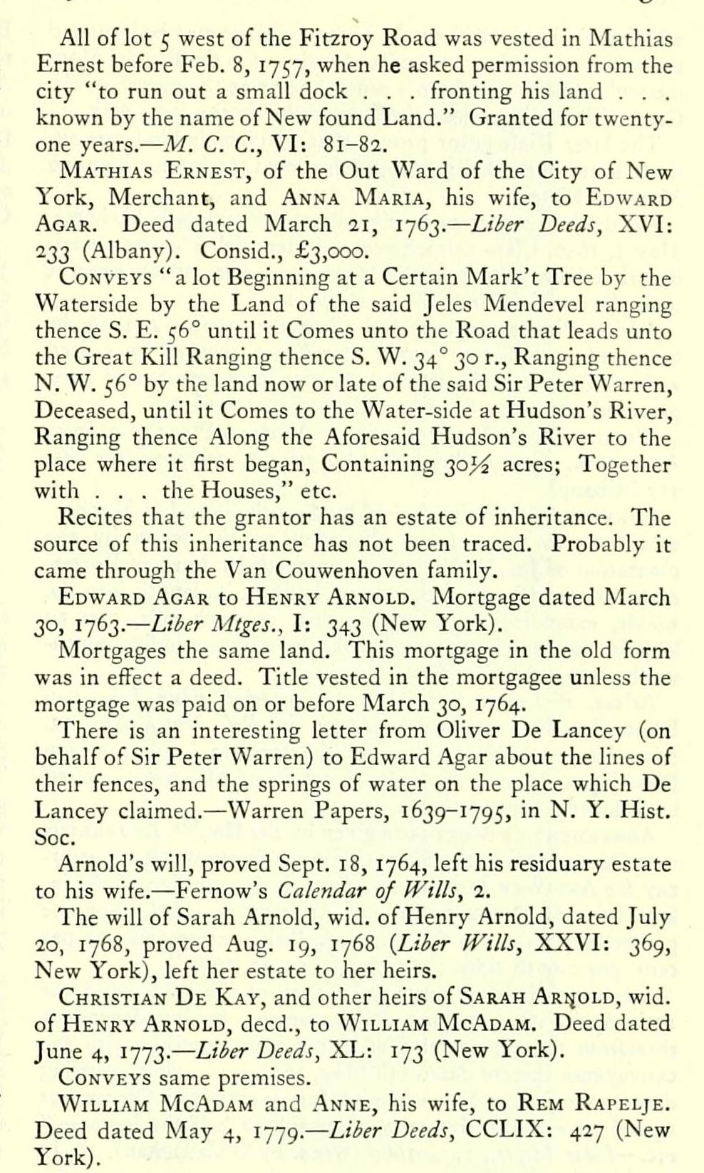
All of lot 5 west of the Fitzroy Road was vested in Mathias Ernest before Feb. 8, 1757, when he asked permission from the city "to run out a small dock . . . fronting his land . . . known by the name of New found Land." Granted for twentyone years.— M. C. C, VI: 81-82.
Mathias Ernest, of the Out Ward of the City of New York, Merchant, and Anna Maria, his wife, to Edward Agar. Deed dated March 2i, 1763. — Liber Deeds, XVI: 233 (Albany). Consid., £3,000.
Conveys " a lot Beginning at a Certain Mark't Tree by the Waterside by the Land of the said Jeles Mendevel ranging thence S. E. 56° until it Comes unto the Road that leads unto the Great Kill Ranging thence S. W. 34° 30 r.. Ranging thence N. W. 56° by the land now or late of the said Sir Peter Warren, Deceased, until it Comes to the Water-side at Hudson's River, Ranging thence Along the Aforesaid Hudson's River to the place where it first began. Containing 30,5^ acres; Together with . . . the Houses," etc.
Recites that the grantor has an estate of inheritance. The source of this inheritance has not been traced. Probably it came through the Van Couwenhoven family.
Edward Agar to Henry Arnold. Mortgage dated March 30, 1763. — Liber Mtges., I: 343 (New York).
Mortgages the same land. This mortgage in the old form was in eflfect a deed. Title vested in the mortgagee unless the mortgage was paid on or before March 30, 1764.
There is an interesting letter from Ohver De Lancey (on behalf of Sir Peter Warren) to Edward Agar about the lines of their fences, and the springs of water on the place which De Lancey claimed. — Warren Papers, 1639-1795, in N. Y. Hist. Soc.
Arnold's will, proved Sept. 18, 1764, left his residuary estate to his wife. — Fernow's Calendar of Wills, 2.
The will of Sarah Arnold, wid. of Henry Arnold, dated July 20, 1768, proved Aug. 19, 1768 {Liber Wills, XXVI: 369, New York), left her estate to her heirs.
Christian De Kay, and other heirs of Sarah Ar(jold, wid. of Henry Arnold, deed., to William McAdam. Deed dated June 4, 1773. — Liber Deeds, XL: 173 (New York).
Conveys same premises.
William McAdam and .^nne, his wife, to Rem Rapelje. Deed dated May 4, 1779. — Liber Deeds, CCLIX: 427 (New York).
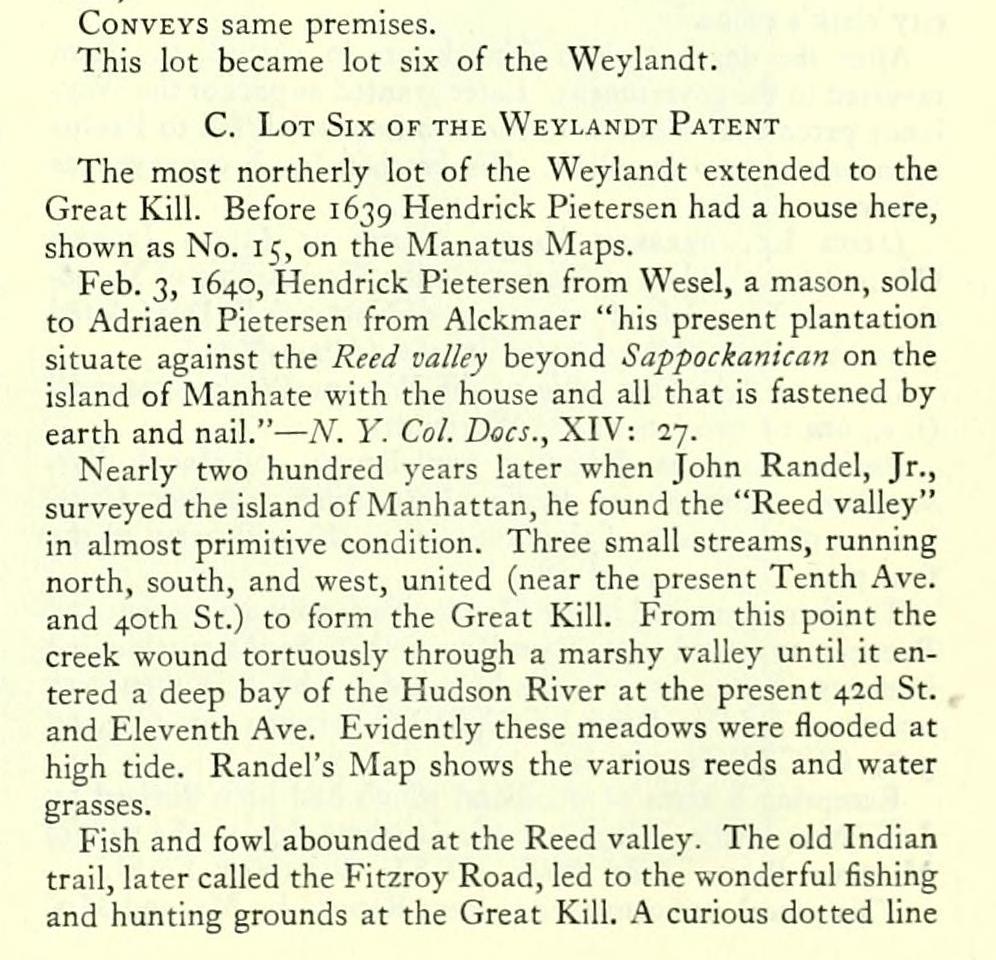
Conveys same premises.
This lot became lot six of the Weylandt.
C. Lot Six of the Weylandt Patent
The most northerly lot of the Weylandt extended to the Great Kill. Before 1639 Hendrick Pietersen had a house here, shown as No. 15, on the Manatus Maps.
Feb. 3, 1640, Hendrick Pietersen from Wesel, a mason, sold to Adriaen Pietersen from Alckmaer "his present plantation situate against the Reed valley beyond Sappockanican on the island of Manhate with the house and all that is fastened by earth and nail." — A'. 1'. Col. Docs., XIV: 27.
Nearly two hundred years later when John Randel, Jr., surveyed the island of Manhattan, he found the "Reed valley" in almost primitive condition. Three small streams, running north, south, and west, united (near the present Tenth Ave. and 40th St.) to form the Great Kill. From this point the creek wound tortuously through a marshy valley until it entered a deep bay of the Hudson River at the present 42d St. and Eleventh Ave. Evidently these meadows were flooded at high tide. Randel's Map shows the various reeds and water grasses.
Fish and fowl abounded at the Reed valley. The old Indian trail, later called the Fitzroy Road, led to the wonderful fishing and hunting grounds at the Great Kill. A curious dotted line which encircles the Kill, on the Manatus Maps may be intended to show the boundary of the Reed valley. On the Randel Map, a circular line drawn from a central point at the mouth of the Great Kill would enclose the Reed valley in the same way.
The later Kieft grant proves that Pietersen's land was entirely south of the Kill; the house is shown too far north on the Manatus Maps. a
Hendrick Pietersen probably regretted having sold his home. May 5, 1 640, Claes Cornelissen and Hendrick Pietersen certified that both parties to the transaction were drunk when it took place. — Cal. Hist. MSS., Dutch, 13.
Adrian Pietersen retained the bouwery. Sept. 2, 1643, he borrowed 350 guilders from Pieter Kolet, secured by a deed with reversionary clause (the old mortgage form), and later procured a patent. See Chronology, Sept. 2, 1643.
WiLLEM KiEFT, Director, etc., to Adriaen Pietersen from Alckmaer. Ground-brief dated April 13, 1647. — Liber GG: 212 (Albany).
Conveys "A certain piece of land on the island of Manhattans near to Sapocanikan, bounded on the south by the plantation of Jan Virginijes, on the north by Jan van Rotterdam; its breadth along the strand is 65 r.; its length into the woods, extending south-east-by-east, on each side, 200 r.; long in the rear in the woods the breadth extending southsouth-west is 65 r."
Ariaen Pietersen van Alckmaer married Elsie Jans van Bresteede, May 17, 1643. — Marr. in Ref. Dutch Ch., 12. After his death his widow sold the farm to Lubbertus van Dincklagen, May 6, 1655. Deed not found of record; recited in following instrument.
Agreement of Mortgage given by the Hon^ile Lubbertus VAN DiNCKLAGH to the Sieur Cornelis Steenwyck, as attorney for Anthony Jansen, of Amsterdam, guardian of the infant heirs of Dirck Schut, of Amsterdam, deed. For the payment of a debt of 675 gl., 4 st., "with interest at two per cent, per month since the 29th of August, 1650."
Steenwyck held as security "a deed of the land dated the 13th April, 1647, written on parchment, having dependent therefrom the provincial Seal in red wax, together with the conveyance thereof dated 6th May, 1655 . . . and a writing dated 21st July, 1650, whereby Jan Jansen van Oosterhout agreed to work the bouwery aforesaid for half the increase," etc. — Liier Mtges., 1654-1660 (trans, by O'Callaghan), 16, in city clerk's office.
After the death of Van Dincklagen, in 1657-8, the farm reverted to the government. Later granted as part of the Weylandt patent. It was one of the two lots which fell to Paulus Leendertsen van der Grift. His brother Jacob conveyed as follows:
Jacob Leenderssen Vande Grift to Jellis Jansen (Mandeville), "lateof fflatland in the West Riding of Yorkeshire upon Long Island, at present of Nortwick." Deed dated June 21, 1679. — Liber Deeds, V: 186 (Albany).
Conveys "the One halfe of the Wey or Pasture ground" (('. e., one of two lots at the Weylandt).
Recites same as Joh.innes van Brugh and Jacob Vervangher, attorneys for Paulus Leendersen van der Grift, brother of the party of the first part to the said party of the first part.
The farm remained in the Mandeville family over a century. Between 1779 and 1787, Rem Rapelje bought the outstanding interests of the heirs of Jellis Mandeville who were then very numerous. — Liber Deeds, CCXCVI, between pp. 301 and 328; CCCXVII: 357, &c.
Excepting 6 acres of woodland which had been devised by Jellis Mandeville, in 1778, to his daughter, Mary, the wife of Matthew Buys.— Z,;^fr l^l^ills, XXXI: 204 (New York).
This parcel was conveyed to Rem Rapelje by Mr. and Mrs.
Buyce, April 30, 178 1. The description begins "near a great rock ig ch., 57 1. from the road that leads to the Great Kills." A copy of Maerschalck's survey is in the Bancker Collection, in N. Y. P. L. There was evidently a later survey by Bancker (not found), from which the description in the deed was drawn. The great rock is shown on the Randel Map, at the south-west corner of Tenth Ave. and 38th St. — Liber Deeds, CCXCVI: 313, New York.
The Rapelje farm house stood east of Eleventh Ave. between 34th and 35th Sts. There is a picture of the old house and a charming little story, "The Last Tile of the Rapelyea House," in Greatorex, Old New York from the Battery to Bloomingdale. Many entries about the farm appear in the Chronology (consult index).
The further real estate history is given in the notes in an appendix to Spielman and Brush, Certified Copies oj Original Maps. Map No. 68 is also reproduced in that volume.
Block Check List. 1089-1071-1050-1031-758-679-1089.
The Glass House farm comprised
A. Lot four of the Weylandt patent west of the old road to Greenwich, the Fitzroy Road.
B. Lot five of the same patent west of the road.
C. Lot six of the same patent west of the road.
A brief history of the Weylandt patent will be found with the Jacobus Van Orden farm.
A. Lot Four of the Weylandt Patent Lot four of the Weylandt was the most northerly of two lots
belonging to Cornells van Ruyven.
CoRNELis Van Ruyven to Teunis Idusse. Deed recorded
June 22, 1674. — Collections N. Y. Hist. Soc. (1913), 29.
Conveys "one sixth (J-e) share in the meadowland situated on this island Manhattans between Clabbord's Valley and the Great Kill, of the same extent as expressed in the grant by Govr Nicolls, dated Aug. i, 1668."
Teunis Idusse to Johannes Thomasse. Deed dated May 2g, 1698. (The date should read 1688; delivered i6g8.) Not found of record: original in De Lancey Papers, 1647-1804, in N. Y. Hist. Soc.
Conveys a parcel of meadow land. This was the lot called lot four on this compilation.
Johannes Thomaszen, of Amsterdam, married Aachtje Jacobs, of Amersfort, Oct. 31, 1677. Both then living at Sapohanican. — Mair. in Ref. Dutch Ch., 43.
Their children adopted the name of Sammon. — Purple, Ancient Families of N. Y., 23.
Jacob Sammon, yeoman, and Catherine, his wife, Johannes Sammon, eldest son of said Jacob, to James Henderson, "Doctor in Physick." Deed dated Sept. 20, 1737. Not found of record. Original in De Peyster Deeds, Vol. I, in N. Y. Hist. Soc.
Recites foregoing deed from Teunis Idusse to Johannes Thomasse, father of the above named Jacob Sammon. Recites will of Jacob Tomasse, March 25, 171 1; that Jacob Sammon purchased the interest of the other heirs for £ I40,etc.
This deed made in duplicate, the old form of lease and release, recites the will of Jacob Thomasse (probably a clerical error for Johannes Thomasse). The duplicate instrument, made one day earlier, is in De Peyster Papers, Vol. XII, in N. Y. Hist. Soc.
The following description covers only that part of the lot west of the road.
Conveys "one other piece or parcel of land containing about 25 acres, more or less, scituate and being in the Outward of the said City of New York, being part of the land heretofore recited and more particularly expressed in the deed from Teunis Edissen to the said Johannes Thomassen, (&c.)
"Beginning at the South-west bounds of Wessel Vanardas lott of ground on the west side of the road that leads round the Tower, thence N. 27° E. 7 ch., 30 1.; thence N. 55° 45' W. 40 ch., 50 1. to Hudsons River; thence along Hudsons River S. 25° 30' W. 6 ch.; thence S. 15° W. I ch., 80 1. to the Lott of said Wessel Vanarda; thence along Wessel Vanarda, S. 56° E. 39 ch., 80 links to place where it first begun."
Will of James Henderson. Dated Oct. 7, 1743; proved Dec. l6, 1743. — Li/>er JVitls, XV: 150 (New York).
TiESSE Henderson and Margaret Henderson, Executrices of James Henderson, deed., to Peter Warren, Esq. Deed dated Sept. 25, 1744. Not found of record. Original in Warren Deeds, 1691-1784, in N. Y. Hist. Soc.
Conveys same as preceding deed.
WiLLOUGHBY, Earl of Abingdon, by his attorney and trustee, John Watts, to Rem Rapelye. Deeds of lease and release dated March 24-25, 1789. — Liber Deeds, CCLIX: 422, 451-60 (New York).
The Earl of Abingdon had married a daughter of Sir Peter Warren.
B. Lot Five of the Weylandt Patent
The most southerly lot patented to Paulus Leendertsen van der Grift.
Jacob Leenderssen Vande Grift to Johannes Van CouwENHOVEN. Deed dated Aug. 21, 1677. Not found of record. Recited in Liber Deeds, V: 186 (Albany).
Conveys one-half of the Wey or Pasture Ground (i. e. one of two lots at the Wey).
Recites deed, Johannes Van Brugh and Jacob Vervangher, attorneys for Paulus Leendersen van der Grift, to Jacob Leendersen Van der Grift.
All of lot 5 west of the Fitzroy Road was vested in Mathias Ernest before Feb. 8, 1757, when he asked permission from the city "to run out a small dock . . . fronting his land . . . known by the name of New found Land." Granted for twentyone years.— M. C. C, VI: 81-82.
Mathias Ernest, of the Out Ward of the City of New York, Merchant, and Anna Maria, his wife, to Edward Agar. Deed dated March 2i, 1763. — Liber Deeds, XVI: 233 (Albany). Consid., £3,000.
Conveys " a lot Beginning at a Certain Mark't Tree by the Waterside by the Land of the said Jeles Mendevel ranging thence S. E. 56° until it Comes unto the Road that leads unto the Great Kill Ranging thence S. W. 34° 30 r.. Ranging thence N. W. 56° by the land now or late of the said Sir Peter Warren, Deceased, until it Comes to the Water-side at Hudson's River, Ranging thence Along the Aforesaid Hudson's River to the place where it first began. Containing 30,5^ acres; Together with . . . the Houses," etc.
Recites that the grantor has an estate of inheritance. The source of this inheritance has not been traced. Probably it came through the Van Couwenhoven family.
Edward Agar to Henry Arnold. Mortgage dated March 30, 1763. — Liber Mtges., I: 343 (New York).
Mortgages the same land. This mortgage in the old form was in eflfect a deed. Title vested in the mortgagee unless the mortgage was paid on or before March 30, 1764.
There is an interesting letter from Ohver De Lancey (on behalf of Sir Peter Warren) to Edward Agar about the lines of their fences, and the springs of water on the place which De Lancey claimed. — Warren Papers, 1639-1795, in N. Y. Hist. Soc.
Arnold's will, proved Sept. 18, 1764, left his residuary estate to his wife. — Fernow's Calendar of Wills, 2.
The will of Sarah Arnold, wid. of Henry Arnold, dated July 20, 1768, proved Aug. 19, 1768 {Liber Wills, XXVI: 369, New York), left her estate to her heirs.
Christian De Kay, and other heirs of Sarah Ar(jold, wid. of Henry Arnold, deed., to William McAdam. Deed dated June 4, 1773. — Liber Deeds, XL: 173 (New York).
Conveys same premises.
William McAdam and .^nne, his wife, to Rem Rapelje. Deed dated May 4, 1779. — Liber Deeds, CCLIX: 427 (New York).
Conveys same premises.
This lot became lot six of the Weylandt.
C. Lot Six of the Weylandt Patent
The most northerly lot of the Weylandt extended to the Great Kill. Before 1639 Hendrick Pietersen had a house here, shown as No. 15, on the Manatus Maps.
Feb. 3, 1640, Hendrick Pietersen from Wesel, a mason, sold to Adriaen Pietersen from Alckmaer "his present plantation situate against the Reed valley beyond Sappockanican on the island of Manhate with the house and all that is fastened by earth and nail." — A'. 1'. Col. Docs., XIV: 27.
Nearly two hundred years later when John Randel, Jr., surveyed the island of Manhattan, he found the "Reed valley" in almost primitive condition. Three small streams, running north, south, and west, united (near the present Tenth Ave. and 40th St.) to form the Great Kill. From this point the creek wound tortuously through a marshy valley until it entered a deep bay of the Hudson River at the present 42d St. and Eleventh Ave. Evidently these meadows were flooded at high tide. Randel's Map shows the various reeds and water grasses.
Fish and fowl abounded at the Reed valley. The old Indian trail, later called the Fitzroy Road, led to the wonderful fishing and hunting grounds at the Great Kill. A curious dotted line which encircles the Kill, on the Manatus Maps may be intended to show the boundary of the Reed valley. On the Randel Map, a circular line drawn from a central point at the mouth of the Great Kill would enclose the Reed valley in the same way.
The later Kieft grant proves that Pietersen's land was entirely south of the Kill; the house is shown too far north on the Manatus Maps. a
Hendrick Pietersen probably regretted having sold his home. May 5, 1 640, Claes Cornelissen and Hendrick Pietersen certified that both parties to the transaction were drunk when it took place. — Cal. Hist. MSS., Dutch, 13.
Adrian Pietersen retained the bouwery. Sept. 2, 1643, he borrowed 350 guilders from Pieter Kolet, secured by a deed with reversionary clause (the old mortgage form), and later procured a patent. See Chronology, Sept. 2, 1643.
WiLLEM KiEFT, Director, etc., to Adriaen Pietersen from Alckmaer. Ground-brief dated April 13, 1647. — Liber GG: 212 (Albany).
Conveys "A certain piece of land on the island of Manhattans near to Sapocanikan, bounded on the south by the plantation of Jan Virginijes, on the north by Jan van Rotterdam; its breadth along the strand is 65 r.; its length into the woods, extending south-east-by-east, on each side, 200 r.; long in the rear in the woods the breadth extending southsouth-west is 65 r."
Ariaen Pietersen van Alckmaer married Elsie Jans van Bresteede, May 17, 1643. — Marr. in Ref. Dutch Ch., 12. After his death his widow sold the farm to Lubbertus van Dincklagen, May 6, 1655. Deed not found of record; recited in following instrument.
Agreement of Mortgage given by the Hon^ile Lubbertus VAN DiNCKLAGH to the Sieur Cornelis Steenwyck, as attorney for Anthony Jansen, of Amsterdam, guardian of the infant heirs of Dirck Schut, of Amsterdam, deed. For the payment of a debt of 675 gl., 4 st., "with interest at two per cent, per month since the 29th of August, 1650."
Steenwyck held as security "a deed of the land dated the 13th April, 1647, written on parchment, having dependent therefrom the provincial Seal in red wax, together with the conveyance thereof dated 6th May, 1655 . . . and a writing dated 21st July, 1650, whereby Jan Jansen van Oosterhout agreed to work the bouwery aforesaid for half the increase," etc. — Liier Mtges., 1654-1660 (trans, by O'Callaghan), 16, in city clerk's office.
After the death of Van Dincklagen, in 1657-8, the farm reverted to the government. Later granted as part of the Weylandt patent. It was one of the two lots which fell to Paulus Leendertsen van der Grift. His brother Jacob conveyed as follows:
Jacob Leenderssen Vande Grift to Jellis Jansen (Mandeville), "lateof fflatland in the West Riding of Yorkeshire upon Long Island, at present of Nortwick." Deed dated June 21, 1679. — Liber Deeds, V: 186 (Albany).
Conveys "the One halfe of the Wey or Pasture ground" (('. e., one of two lots at the Weylandt).
Recites same as Joh.innes van Brugh and Jacob Vervangher, attorneys for Paulus Leendersen van der Grift, brother of the party of the first part to the said party of the first part.
The farm remained in the Mandeville family over a century. Between 1779 and 1787, Rem Rapelje bought the outstanding interests of the heirs of Jellis Mandeville who were then very numerous. — Liber Deeds, CCXCVI, between pp. 301 and 328; CCCXVII: 357, &c.
Excepting 6 acres of woodland which had been devised by Jellis Mandeville, in 1778, to his daughter, Mary, the wife of Matthew Buys.— Z,;^fr l^l^ills, XXXI: 204 (New York).
This parcel was conveyed to Rem Rapelje by Mr. and Mrs.
Buyce, April 30, 178 1. The description begins "near a great rock ig ch., 57 1. from the road that leads to the Great Kills." A copy of Maerschalck's survey is in the Bancker Collection, in N. Y. P. L. There was evidently a later survey by Bancker (not found), from which the description in the deed was drawn. The great rock is shown on the Randel Map, at the south-west corner of Tenth Ave. and 38th St. — Liber Deeds, CCXCVI: 313, New York.
The Rapelje farm house stood east of Eleventh Ave. between 34th and 35th Sts. There is a picture of the old house and a charming little story, "The Last Tile of the Rapelyea House," in Greatorex, Old New York from the Battery to Bloomingdale. Many entries about the farm appear in the Chronology (consult index).
The further real estate history is given in the notes in an appendix to Spielman and Brush, Certified Copies oj Original Maps. Map No. 68 is also reproduced in that volume.