Lot
Oliver De Lancey Farm
Lot Group
Original Grants and Farms
Property Was Used in 1660 For:
Original Grants and Farms Document(s)
Grant Lot Document(s)
Tax Lot Events
Full Stokes Entry (See images below)
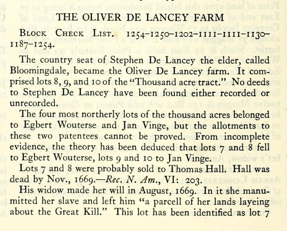
THE OLIVER DE LANCEY FARM
Block Check List. 1254-1250-1202-1111-1111-1130II 87-1 254.
The country seat of Stephen De Lancey the elder, called Bloomingdale, became the Oliver De Lancey farm. It comprised lots 8, 9, and 10 of the "Thousand acre tract." No deeds to Stephen De Lancey have been found either recorded or unrecorded.
The four most northerly lots of the thousand acres belonged to Egbert Wouterse and Jan Vinge, but the allotments to these two patentees cannot be proved. From incomplete evidence, the theory has been deduced that lots 7 and 8 fell to Egbert Wouterse, lots 9 and 10 to Jan Vinge.
Lots 7 and 8 were probably sold to Thomas Hall. Hall was dead by Nov., 1669. — Rec. N. Am., VI: 203.
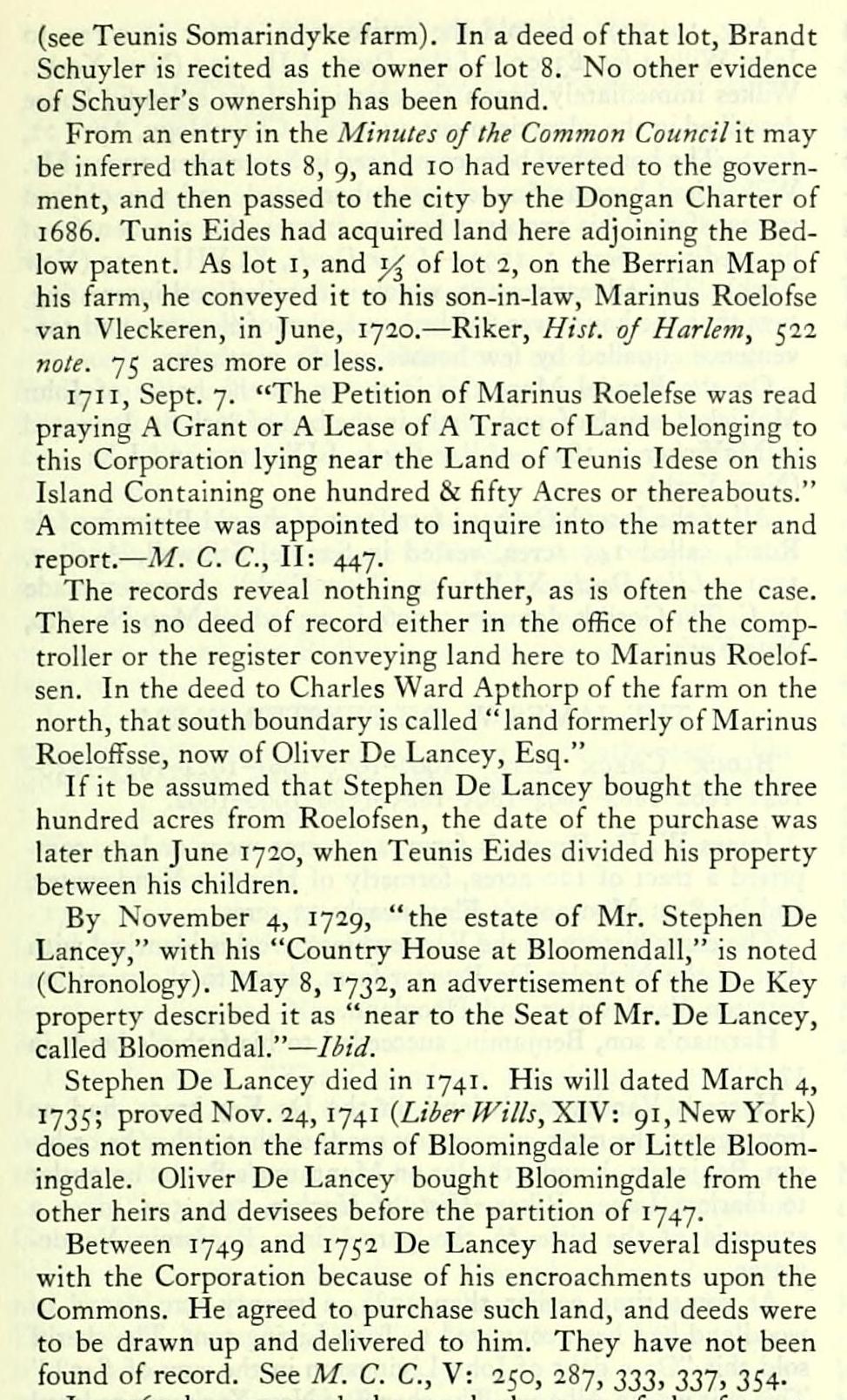
His widow made her will in August, 1669. In it she manumitted her slave and left him "a parcell of her lands layeing about the Great Kill." This lot has been identified as lot 7 (see Teunis Somarindyke farm). In a deed of that lot, Brandt Schuyler is recited as the owner of lot 8. No other evidence of Schuyler's ownership has been found.
From an entry in the Minutes of the Common Council \t may be inferred that lots 8, 9, and 10 had reverted to the government, and then passed to the city by the Dongan Charter of 1686. Tunis Eides had acquired land here adjoining the Bedlow patent. As lot i, and i,^ of lot 2, on the Berrian Map of his farm, he conveyed it to his son-in-law, Marinus Roelofse van Vleckeren, in June, 1720. — Riker, Hist, oj Harlem, 522 note. 75 acres more or less.
171 1, Sept. 7. "The Petition of Marinus Roelefse was read praying A Grant or A Lease of A Tract of Land belonging to this Corporation lying near the Land of Teunis Idese on this Island Containing one hundred & fifty Acres or thereabouts." A committee was appointed to inquire into the matter and report. — M. C. C, II: 447.
The records reveal nothing further, as is often the case. There is no deed of record either in the office of the comptroller or the register conveying land here to Marinus Roelofsen. In the deed to Charles Ward Apthorp of the farm on the north, that south boundary is called "land formerly of Marinus Roeloffsse, now of Oliver De Lancey, Esq."
If it be assumed that Stephen De Lancey bought the three hundred acres from Roelofsen, the date of the purchase was later than June 1720, when Teunis Eides divided his property between his children.
By November 4, 1729, "the estate of Mr. Stephen De Lancey," with his "Country House at Bloomendall," is noted (Chronology). May 8, 1732, an advertisement of the De Key property described it as "near to the Seat of Mr. De Lancey, called Bloomendal." — liiJ.
Stephen De Lancey died in 1741. His will dated March 4, 1735; proved Nov. 24, 1741 (Z./^(r^'///j, XIV: 91, New York) does not mention the farms of Bloomingdale or Little Bloomingdale. Oliver De Lancey bought Bloomingdale from the other heirs and devisees before the partition of 1747.
Between 1749 and 1752 De Lancey had several disputes with the Corporation because of his encroachments upon the Commons. He agreed to purchase such land, and deeds were to be drawn up and delivered to him. They have not been found of record. See M. C. C, V: 250, 287, 233, 337, 354-
In 1763 he conveyed the southerly part of the farm to Charles Ward Apthorp by the two following deeds.
Oliver de Lancey and Phila, his wife, to Charles Ward Apthorpe. Deed dated May 11, 1763. — Liier Deeds, LVII: 245 (New York). Cons. £4600.
Conveys "All that certain Messuage or dwelling house and tract of Land ... on the east side of Hudsons River at a place commonly called Bloomendall."
Oliver de Lancey and wife to Charles Ward Apthorp. Deed dated June 12, 1763. — Liier Deeds, CCIX: 259 (New York). Cons. £450.
Both deeds recite: "Part of a larger tract which the said Oliver Delancey purchased in fee from the Executors, Heirs and Devisees of Stephen Delancey the elder, dec'd, or some of them."
The descriptions are long, evidently drawn from an accurate survey, though no surveyor's name is given. As protracted to the scale of the Randel Map, they are found to be contiguous and to agree with the Randel survey. 153 acres more or less.
As Charles Ward Apthorp already owned the large farm to the north of De Lancey, on which there was a good house, it is useless to conjecture which house he occupied. However, he chose the upper farm for a country seat, built there the Apthorp mansion in 1764, and sold the old house to Gerrit Striker. The house on the De Lancey farm he sold to his brother-in-law, James McEvers.
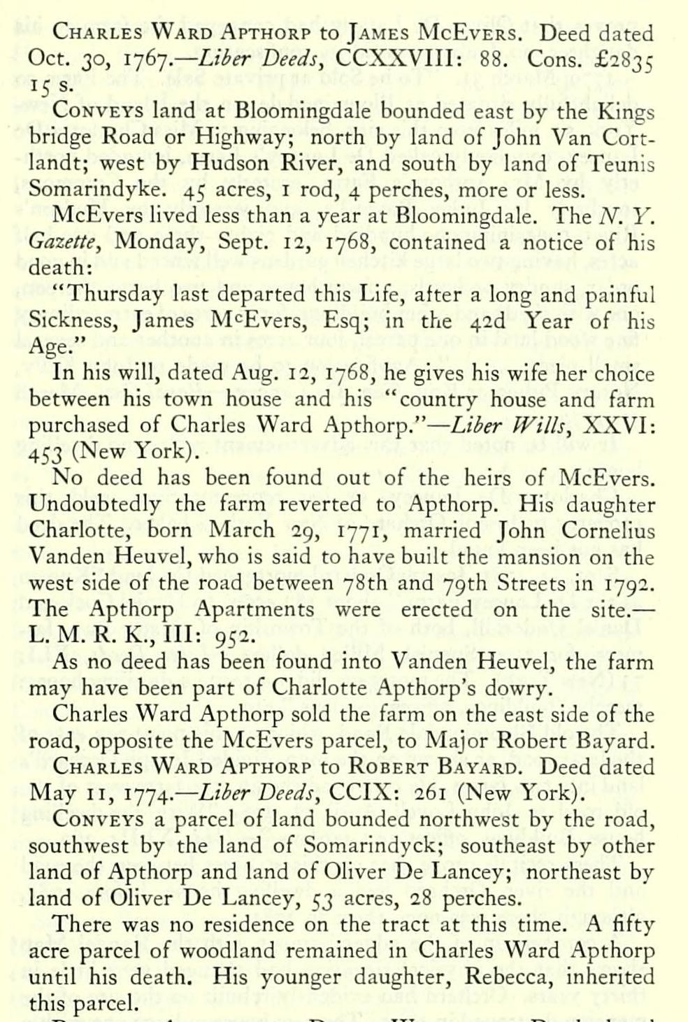
Charles Ward Apthorp to James McEvers. Deed dated Oct. 30, 1767.— Liier Deeds, CCXXVIII: 88. Cons. £2835 15 s.
Conveys land at Bloomingdale bounded east by the Kings bridge Road or Highway; north by land of John Van Cortlandt; west by Hudson River, and south by land of Teunis Somarindyke. 45 acres, i rod, 4 perches, more or less.
McEvers lived less than a year at Bloomingdale. The A''. Y. Gazette, Monday, Sept. 12, 1768, contained a notice of his death:
"Thursday last departed this Life, after a long and painful Sickness, James M<:Evers, Esq; in the 42d Year of his Age." ^ ^
In his will, dated Aug. 12, 1768, he gives his wife her choice between his town house and his "country house and farm purchased of Charles Ward Apthorp." — Liier Wills, XXVI: 453 (New York).
No deed has been found out of the heirs of McEvers. Undoubtedly the farm reverted to Apthorp. His daughter Charlotte, born March 2g, 1771, married John Cornelius Vanden Heuvel, who is said to have built the mansion on the west side of the road between 78th and 79th Streets in 1792. The .Apthorp Apartments were erected on the site. — L. M. R. K., Ill: 952.
As no deed has been found into Vanden Heuvel, the farm may have been part of Charlotte Apthorp's dowry.
Charles Ward Apthorp sold the farm on the east side of the road, opposite the McEvers parcel, to Major Robert Bayard.
Charles Ward Apthorp to Robert Bayard. Deed dated May II, 1774. — Liier Deeds, CCIX: 261 (New York).
Conveys a parcel of land bounded northwest by the road, southwest by the land of Somarindyck; southeast by other land of Apthorp and land of Oliver De Lancey; northeast by land of Oliver De Lancey, 53 acres, 28 perches.
There was no residence on the tract at this time. A fifty acre parcel of woodland remained in Charles Ward Apthorp until his death. His younger daughter, Rebecca, inherited this parcel.
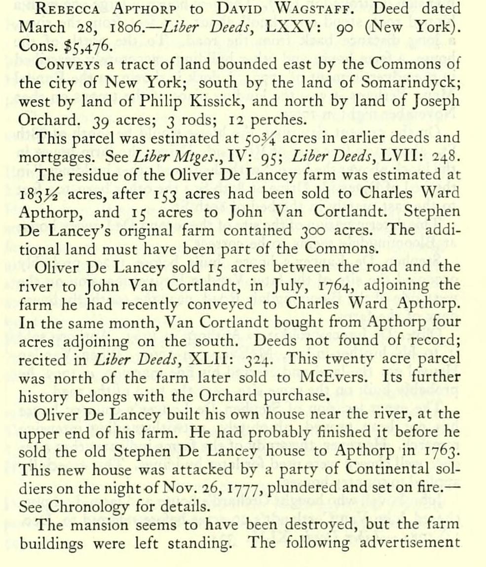
Rebecca Apthorp to David Wagstaff. Deed dated March 28, 1S06.— Liier Deeds, LXXV: 90 (New York). Cons. $5,476.
Conveys a tract of land bounded east by the Commons ol the city of New York; south by the land of Somarindyck; west by land of Philip Kissick, and north by land of Joseph Orchard. 39 acres; 3 rods; 12 perches.
This parcel was estimated at 50,3-4 acres in earlier deeds and mortgages. See Liier Mtges.,W: 95; Liier Deeds,W\\: 248.
The residue of the Ohver De Lancey farm was estimated at 183,5-^ acres, after 153 acres had been sold to Charles Ward Apthorp, and 15 acres to John Van Cortlandt. Stephen De Lancey's original farm contained 300 acres. The additional land must have been part of the Commons.
Oliver De Lancey sold 15 acres between the road and the river to John Van Cortlandt, in July, 1764, adjoining the farm he had recently conveyed to Charles Ward .'Apthorp. In the same month, Van Cortlandt bought from Apthorp four acres adjoining on the south. Deeds not found of record; recited in Liier Deeds, XLII: 324. This twenty acre parcel was north of the farm later sold to McEvers. Its further history belongs with the Orchard purchase.
Oliver De Lancey built his own house near the river, at the upper end of his farm. He had probably finished it before he sold the old Stephen De Lancey house to Apthorp in 1763. This new house was attacked by a party of Continental soldiers on the night of Nov. 26, 1777, plundered and set on fire.— See Chronology for details.
The mansion seems to have been destroyed, but the farm buildings were left standing. The following advertisement proves that Oliver De Lancey had conveyed the farm to his daughter, no doubt to avoid its confiscation.
1779, March 31. "To be Sold at private Sale. The Farm so delightfully situated at Bloomingdale, on the Island of NewYork, six miles from this city, belonging to Miss Charlotte De Lancey, commonly called De Lancey's Farm, bounded northerly by Mr. Apthorp's Farm, easterly by the Commons, southerly by Judge Bayard's, and westerly by Hudson's River, containing one hundred and eighty-three and one-half acres, having two large kitchen gardens well fenced and in good order, sundry orchards, a farm house and two barns thereon, one with sheds and other buildings, forty acres of extraordinary fine wood land in one parcel, four acres in another and several small pieces. ..." Application to be made to John Kelly, Notary Public or Brig. Gen. De Lancey. — Royal Gaz., March
31. 1779-
It will be noted that this advertisement recites no dwelling house.
Charlotte De Lancey, or her representatives, sold this property to Joseph Orchard of New York, a baker. The deed has not been found.
Sept. II, 1781, Joseph Orchard mortgaged the land "Known as the De Lancey Farm," about 183 acres, to Daniel Cock and Daniel Underbill, both of the Township of Oyster Bay, farmers, for 2500 Spanish Milled dollars. — Liier Deeds, XLI: 73 (New York). The mortgage did not recite a dwelling house: merely "buildings, offices, gardens," etc.
The old Bloomingdale Road, which at this point ran east of the later road, as shown on the map, divided Joseph Orchard's land into two farms. He conveyed the 40 acre farm west of the old road to John Lovell, April la, 1785 "With the dwelling house, Buildings, offices and gardens." — IliiJ., XLII: 360.
These recitals prove that on this 40 acres between the road and the river. Orchard had a dwelling house, before 1785, although there was none there in 1781.
A comparison of the advertisement with the Randel Map shows that the physical situation had changed very little in thirty years. Orchard had evidently rebuilt on the site of the mansion destroyed in 1777. The new house, a large one with a hipped roof, stood on a knoll about 400 feet from the river, a long distance back from the road. To the north of the house, a farm house and other buildings, accurately described in the advertisement of 1779. A dock is shown on the Randel Map. Perhaps it was the landing place of the troops on that November night in 1777.
On the present city plan, the house would be south of 88th St., about 100 feet east of Riverside Drive; the farm house in the block above; the barn, "with sheds and other buildings," in the bed of Riverside Drive at 89th St.; the other barn 100 feet to the east, partly in the bed of 89th St.
This determination of the site of the second De Lancey house at Bloomingdale seems to be correct.
Stephen De Lancey's house, built beiore 1729, probably occupied the site of the later Vanden Heuvel mansion on the west side of the Bloomingdale Road, near the southerly boundary of the farm.
Oliver De Lancey sold it to Apthorp in 1763. Apthorp sold it to his brother-in-law, McEvers, in 1767. When Vanden Heuvel got the land and erected his fine mansion, c. 1792, he probably built on the same site, near the turn of the road.
The exact location of Stephen De Lancey's country house has not been proved, absolutely, notwithstanding intensive research. However, the study of the farms indicates that sites once well chosen were used for later buildings. This especially applied to country houses.
John Lovel, who bought Orchard's house and farm, had purch.ased John Van Cortlandt's 20 acres before referred to, Dec. IS, 17^4-— Lil/er Deeds, XLU: 324.
Aug. 19, 1791, he sold the entire tract, about 60 acres, to John Wilkes for £3500. — Li/>er Deeds, LII: 493 (New York). Wilkes immediately began the erection of the splendid house described in the advertisement quoted in Chronology, April 22, 1793. The house had been completed in September, 1792. Mr. Wilkes had become financially embarrassed, and was obliged to transfer all his property here to trustees for the benefit of his creditors, Sept. i, 1792. — Liier Deeds, XLVIII: 359 (New York). The advertisement, which is detailed and interesting, says that the house was finished on a plan of elegance and convenience equalled by few houses on the continent.
On the Randel Map, this is shown as the house of John McVicker, south of, and partly in the bed of 86th St. It vested in McVicker in 1801. — Liier Deeds, LIX: 177 and LX: 460 (New York).
All of the Joseph Orchard farm east of the old Bloomingdale Road, called 145 acres, vested in Samuel Stillwell, April 7, 1791. — Lihr Deeds, XLVI: 549 (New York). A survey made by C. Th. Goerck, January, 1796, is copied on Map No. 610, New York.
Block Check List. 1254-1250-1202-1111-1111-1130II 87-1 254.
The country seat of Stephen De Lancey the elder, called Bloomingdale, became the Oliver De Lancey farm. It comprised lots 8, 9, and 10 of the "Thousand acre tract." No deeds to Stephen De Lancey have been found either recorded or unrecorded.
The four most northerly lots of the thousand acres belonged to Egbert Wouterse and Jan Vinge, but the allotments to these two patentees cannot be proved. From incomplete evidence, the theory has been deduced that lots 7 and 8 fell to Egbert Wouterse, lots 9 and 10 to Jan Vinge.
Lots 7 and 8 were probably sold to Thomas Hall. Hall was dead by Nov., 1669. — Rec. N. Am., VI: 203.
His widow made her will in August, 1669. In it she manumitted her slave and left him "a parcell of her lands layeing about the Great Kill." This lot has been identified as lot 7 (see Teunis Somarindyke farm). In a deed of that lot, Brandt Schuyler is recited as the owner of lot 8. No other evidence of Schuyler's ownership has been found.
From an entry in the Minutes of the Common Council \t may be inferred that lots 8, 9, and 10 had reverted to the government, and then passed to the city by the Dongan Charter of 1686. Tunis Eides had acquired land here adjoining the Bedlow patent. As lot i, and i,^ of lot 2, on the Berrian Map of his farm, he conveyed it to his son-in-law, Marinus Roelofse van Vleckeren, in June, 1720. — Riker, Hist, oj Harlem, 522 note. 75 acres more or less.
171 1, Sept. 7. "The Petition of Marinus Roelefse was read praying A Grant or A Lease of A Tract of Land belonging to this Corporation lying near the Land of Teunis Idese on this Island Containing one hundred & fifty Acres or thereabouts." A committee was appointed to inquire into the matter and report. — M. C. C, II: 447.
The records reveal nothing further, as is often the case. There is no deed of record either in the office of the comptroller or the register conveying land here to Marinus Roelofsen. In the deed to Charles Ward Apthorp of the farm on the north, that south boundary is called "land formerly of Marinus Roeloffsse, now of Oliver De Lancey, Esq."
If it be assumed that Stephen De Lancey bought the three hundred acres from Roelofsen, the date of the purchase was later than June 1720, when Teunis Eides divided his property between his children.
By November 4, 1729, "the estate of Mr. Stephen De Lancey," with his "Country House at Bloomendall," is noted (Chronology). May 8, 1732, an advertisement of the De Key property described it as "near to the Seat of Mr. De Lancey, called Bloomendal." — liiJ.
Stephen De Lancey died in 1741. His will dated March 4, 1735; proved Nov. 24, 1741 (Z./^(r^'///j, XIV: 91, New York) does not mention the farms of Bloomingdale or Little Bloomingdale. Oliver De Lancey bought Bloomingdale from the other heirs and devisees before the partition of 1747.
Between 1749 and 1752 De Lancey had several disputes with the Corporation because of his encroachments upon the Commons. He agreed to purchase such land, and deeds were to be drawn up and delivered to him. They have not been found of record. See M. C. C, V: 250, 287, 233, 337, 354-
In 1763 he conveyed the southerly part of the farm to Charles Ward Apthorp by the two following deeds.
Oliver de Lancey and Phila, his wife, to Charles Ward Apthorpe. Deed dated May 11, 1763. — Liier Deeds, LVII: 245 (New York). Cons. £4600.
Conveys "All that certain Messuage or dwelling house and tract of Land ... on the east side of Hudsons River at a place commonly called Bloomendall."
Oliver de Lancey and wife to Charles Ward Apthorp. Deed dated June 12, 1763. — Liier Deeds, CCIX: 259 (New York). Cons. £450.
Both deeds recite: "Part of a larger tract which the said Oliver Delancey purchased in fee from the Executors, Heirs and Devisees of Stephen Delancey the elder, dec'd, or some of them."
The descriptions are long, evidently drawn from an accurate survey, though no surveyor's name is given. As protracted to the scale of the Randel Map, they are found to be contiguous and to agree with the Randel survey. 153 acres more or less.
As Charles Ward Apthorp already owned the large farm to the north of De Lancey, on which there was a good house, it is useless to conjecture which house he occupied. However, he chose the upper farm for a country seat, built there the Apthorp mansion in 1764, and sold the old house to Gerrit Striker. The house on the De Lancey farm he sold to his brother-in-law, James McEvers.
Charles Ward Apthorp to James McEvers. Deed dated Oct. 30, 1767.— Liier Deeds, CCXXVIII: 88. Cons. £2835 15 s.
Conveys land at Bloomingdale bounded east by the Kings bridge Road or Highway; north by land of John Van Cortlandt; west by Hudson River, and south by land of Teunis Somarindyke. 45 acres, i rod, 4 perches, more or less.
McEvers lived less than a year at Bloomingdale. The A''. Y. Gazette, Monday, Sept. 12, 1768, contained a notice of his death:
"Thursday last departed this Life, after a long and painful Sickness, James M<:Evers, Esq; in the 42d Year of his Age." ^ ^
In his will, dated Aug. 12, 1768, he gives his wife her choice between his town house and his "country house and farm purchased of Charles Ward Apthorp." — Liier Wills, XXVI: 453 (New York).
No deed has been found out of the heirs of McEvers. Undoubtedly the farm reverted to Apthorp. His daughter Charlotte, born March 2g, 1771, married John Cornelius Vanden Heuvel, who is said to have built the mansion on the west side of the road between 78th and 79th Streets in 1792. The .Apthorp Apartments were erected on the site. — L. M. R. K., Ill: 952.
As no deed has been found into Vanden Heuvel, the farm may have been part of Charlotte Apthorp's dowry.
Charles Ward Apthorp sold the farm on the east side of the road, opposite the McEvers parcel, to Major Robert Bayard.
Charles Ward Apthorp to Robert Bayard. Deed dated May II, 1774. — Liier Deeds, CCIX: 261 (New York).
Conveys a parcel of land bounded northwest by the road, southwest by the land of Somarindyck; southeast by other land of Apthorp and land of Oliver De Lancey; northeast by land of Oliver De Lancey, 53 acres, 28 perches.
There was no residence on the tract at this time. A fifty acre parcel of woodland remained in Charles Ward Apthorp until his death. His younger daughter, Rebecca, inherited this parcel.
Rebecca Apthorp to David Wagstaff. Deed dated March 28, 1S06.— Liier Deeds, LXXV: 90 (New York). Cons. $5,476.
Conveys a tract of land bounded east by the Commons ol the city of New York; south by the land of Somarindyck; west by land of Philip Kissick, and north by land of Joseph Orchard. 39 acres; 3 rods; 12 perches.
This parcel was estimated at 50,3-4 acres in earlier deeds and mortgages. See Liier Mtges.,W: 95; Liier Deeds,W\\: 248.
The residue of the Ohver De Lancey farm was estimated at 183,5-^ acres, after 153 acres had been sold to Charles Ward Apthorp, and 15 acres to John Van Cortlandt. Stephen De Lancey's original farm contained 300 acres. The additional land must have been part of the Commons.
Oliver De Lancey sold 15 acres between the road and the river to John Van Cortlandt, in July, 1764, adjoining the farm he had recently conveyed to Charles Ward .'Apthorp. In the same month, Van Cortlandt bought from Apthorp four acres adjoining on the south. Deeds not found of record; recited in Liier Deeds, XLII: 324. This twenty acre parcel was north of the farm later sold to McEvers. Its further history belongs with the Orchard purchase.
Oliver De Lancey built his own house near the river, at the upper end of his farm. He had probably finished it before he sold the old Stephen De Lancey house to Apthorp in 1763. This new house was attacked by a party of Continental soldiers on the night of Nov. 26, 1777, plundered and set on fire.— See Chronology for details.
The mansion seems to have been destroyed, but the farm buildings were left standing. The following advertisement proves that Oliver De Lancey had conveyed the farm to his daughter, no doubt to avoid its confiscation.
1779, March 31. "To be Sold at private Sale. The Farm so delightfully situated at Bloomingdale, on the Island of NewYork, six miles from this city, belonging to Miss Charlotte De Lancey, commonly called De Lancey's Farm, bounded northerly by Mr. Apthorp's Farm, easterly by the Commons, southerly by Judge Bayard's, and westerly by Hudson's River, containing one hundred and eighty-three and one-half acres, having two large kitchen gardens well fenced and in good order, sundry orchards, a farm house and two barns thereon, one with sheds and other buildings, forty acres of extraordinary fine wood land in one parcel, four acres in another and several small pieces. ..." Application to be made to John Kelly, Notary Public or Brig. Gen. De Lancey. — Royal Gaz., March
31. 1779-
It will be noted that this advertisement recites no dwelling house.
Charlotte De Lancey, or her representatives, sold this property to Joseph Orchard of New York, a baker. The deed has not been found.
Sept. II, 1781, Joseph Orchard mortgaged the land "Known as the De Lancey Farm," about 183 acres, to Daniel Cock and Daniel Underbill, both of the Township of Oyster Bay, farmers, for 2500 Spanish Milled dollars. — Liier Deeds, XLI: 73 (New York). The mortgage did not recite a dwelling house: merely "buildings, offices, gardens," etc.
The old Bloomingdale Road, which at this point ran east of the later road, as shown on the map, divided Joseph Orchard's land into two farms. He conveyed the 40 acre farm west of the old road to John Lovell, April la, 1785 "With the dwelling house, Buildings, offices and gardens." — IliiJ., XLII: 360.
These recitals prove that on this 40 acres between the road and the river. Orchard had a dwelling house, before 1785, although there was none there in 1781.
A comparison of the advertisement with the Randel Map shows that the physical situation had changed very little in thirty years. Orchard had evidently rebuilt on the site of the mansion destroyed in 1777. The new house, a large one with a hipped roof, stood on a knoll about 400 feet from the river, a long distance back from the road. To the north of the house, a farm house and other buildings, accurately described in the advertisement of 1779. A dock is shown on the Randel Map. Perhaps it was the landing place of the troops on that November night in 1777.
On the present city plan, the house would be south of 88th St., about 100 feet east of Riverside Drive; the farm house in the block above; the barn, "with sheds and other buildings," in the bed of Riverside Drive at 89th St.; the other barn 100 feet to the east, partly in the bed of 89th St.
This determination of the site of the second De Lancey house at Bloomingdale seems to be correct.
Stephen De Lancey's house, built beiore 1729, probably occupied the site of the later Vanden Heuvel mansion on the west side of the Bloomingdale Road, near the southerly boundary of the farm.
Oliver De Lancey sold it to Apthorp in 1763. Apthorp sold it to his brother-in-law, McEvers, in 1767. When Vanden Heuvel got the land and erected his fine mansion, c. 1792, he probably built on the same site, near the turn of the road.
The exact location of Stephen De Lancey's country house has not been proved, absolutely, notwithstanding intensive research. However, the study of the farms indicates that sites once well chosen were used for later buildings. This especially applied to country houses.
John Lovel, who bought Orchard's house and farm, had purch.ased John Van Cortlandt's 20 acres before referred to, Dec. IS, 17^4-— Lil/er Deeds, XLU: 324.
Aug. 19, 1791, he sold the entire tract, about 60 acres, to John Wilkes for £3500. — Li/>er Deeds, LII: 493 (New York). Wilkes immediately began the erection of the splendid house described in the advertisement quoted in Chronology, April 22, 1793. The house had been completed in September, 1792. Mr. Wilkes had become financially embarrassed, and was obliged to transfer all his property here to trustees for the benefit of his creditors, Sept. i, 1792. — Liier Deeds, XLVIII: 359 (New York). The advertisement, which is detailed and interesting, says that the house was finished on a plan of elegance and convenience equalled by few houses on the continent.
On the Randel Map, this is shown as the house of John McVicker, south of, and partly in the bed of 86th St. It vested in McVicker in 1801. — Liier Deeds, LIX: 177 and LX: 460 (New York).
All of the Joseph Orchard farm east of the old Bloomingdale Road, called 145 acres, vested in Samuel Stillwell, April 7, 1791. — Lihr Deeds, XLVI: 549 (New York). A survey made by C. Th. Goerck, January, 1796, is copied on Map No. 610, New York.