Lot
Elbert Herring Farm
Lot Group
Original Grants and Farms
Property Was Used in 1660 For:
Original Grants and Farms Document(s)
Grant Lot Document(s)
Tax Lot Events
Full Stokes Entry (See images below)
THE ELBERT HERRING FARM
Block Check List: 585-592-543-541-549-548-545-531529-541-528-585.
This farm, originally somewhat more than one hundred acres in extent, was part of Wouter van Twiller's bouwery. It consisted of two distinct tracts of land separated by the Minetta Water, connected only by a stretch of the old negroes' causeway. The map of the farm made in 1784, No. 105 in the register's office, shows a vestige of this causeway. The Holmes Map of tlie farm, compiled in 1869, localizes it. It crossed West Third St. west of MacDougal St. Minetta St. between Jjleecker St. and Minetta Lane, called the way to go out, formed part of the old causeway.
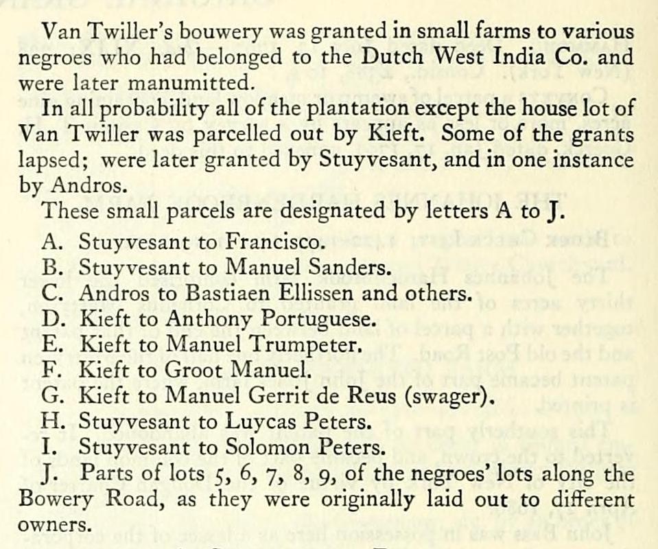
Van Twiller's bouwery was granted in small farms to various negroes who had belonged to the Dutch West India Co. and were later manumitted.
In all probability all of the plantation except the house lot of Van Twiller was parcelled out by Kieft. Some of the grants lapsed; were later granted by Stuyvesant, and in one instance by Andros.
These small parcels are designated by letters A to J.
A. Stuyvesant to Francisco.
B. Stuyvesant to Manuel Sanders.
C. Andros to Bastiaen Ellissen and others.
D. Kieft to Anthony Portuguese.
E. Kieft to Manuel Trumpeter.
F. Kieft to Groot Manuel.
G. Kieft to Manuel Gerrit de Reus (swager). H. Stuyvesant to Luycas Peters.
I. Stuyvesant to Solomon Peters.
J. Parts of lots 5, 6, 7, 8, 9, of the negroes' lots along the Bowery Road, as they were originally laid out to different owners.
A. Stuyvesant to Francisco
Petrus Stuyvesant, Director, etc., to Francisco Negro. Ground-brief dated ,1662. Not found of record ;
recited in confirmation set forth below.
Conveys same as confirmation,
Richard Nicolls, Governour, etc., to Francisco Negro. Confirmation dated Oct. 16, 1667. — Liber Patents, II: 125 (Albany).
Confirms "A certain corner or hooke of land west to [by] y^ land of Symon Congo Neger was in y^ year 1662 given & granted unto Francisco Neger containing in breadth 30 Rods and in length 81 Rods running to Coosin Gerrits swamp."
Francisco Negro to Bastian Ellise. Deed dated April 15, 1684. Not recorded; recited in deed from Bastian Ellison to John Hendricks Brevoort below.
Conveys same as ground-brief.
B. Stuyvesant to Manuel Sanders
Petrus Stuyvesant, Director, etc., to Manuel Sanders. Ground-brief dated , 1662. Not found of record;
recited in confirmation set forth below.
Conveys same as confirmation.
Richard Nicolls, Governour, etc., to Manuel Sanders. Confirmation dated Oct. 16, 1667. — Liber Patents, II: 125 (Albany).
Confirms "a corner or hook stretching northward behind that of Pieter de Sweet, containing in breadth to the fence of Bastiaen de Ramacker, where there is a way to go out, 49^^ r.; in length to the fence of Cossin (Cosyn) Gerrits, swamp, 81 r."
Sanders was affluent enough to employ his medical adviser by the year. In 1673, Gerritt Huygen (who had married the widow of Harmen Wesselsen, a surgeon) sued the negro for the yearly salary of his predecessor and recovered the amount with costs. — Rec.N.Am.,Wl: 11.
Mary van Angola, wid. of Manuel Sanders, to Bastian Ellisse. Deed dated April 15, 1684. Not recorded; recited in instrument following.
Conveys same as confirmation to Manuel Sanders.
Note; April 16, 167 i. Marriage banns: "Manuel Sanders, widower of Mary Sanders, deed, with Maria Angola, widow of Christofl^el Santomme." — Rec. N. Am., VI: 335.
The ground-briefs for parcels A and B, if strictly measured, would not have reached as far as "the road along Jan van Rotterdams to the strand," our present Christopher St. Evidently the negroes were in possession of the land between the road and the cripple-bush.
C. Andros to Bastiaen Ellissen and Others
Edmund Andros, Esq., Governour, etc., to Wolfert Webber, Hendrick Cornelius, and Bastian Ellsen.
Patent dated Sept. 29, 1677. — Liber Patents, IV: 127 (Albany). Original in De Peyster Papers, Vol. I, 1677-1878, in N. Y. Hist. See.
This patent printed in full with the Warren Farm.
Bastiaen de Ramacker (Ellissen) was in possession of the westerly }4 of this patented land, as early as 1662. The confirmation to Sanders so recites.
Bastiaen Elliss, of the Bowery, husbandman, to John Hendrickse Brevoort. Deed dated Nov. 13, 1701. Not found of record. In 1862, the original was stated to be in the possession of E. De Witt, Esq. — Hoffman, Estate and Rights of the Corporation, II: 191.
Conveys same as in following deed.
Hendrick Brevoort and Catharine, his wife; Elias Brevoort and Leah, his wife, to Elbert Herring. Deed dated Dec. 5, 1755. — Liber Deeds, XLI: 125 (New York).
Conveys "a parcel in the Out Ward, Bowery Division, Beginning at a maple tree, marked with 3 notches, i yd.; north spring or run of water called 'The Minetta,' thence S. 23° 3°' W. 2 ch., 28 1. to a white oak tree or sapling marked with 3 notches; thence S. 61° 30' W. 3 ch., 24 1., to an ash tree notched with 3 notches; thence S. 68° W. 2 ch., 36 1. to a gum tree, marked with 3 notches; thence S. 54 W. 2 ch., 93 1. to a maple tree marked with 3 notches; thence 8.62° W. 2 ch., 22 1. to a gum tree; thence S. 74° W. 3 ch., 46 1.; thence S. 79°, W. 4ch., 67I.; thence N. 9° W. 4ch., 57I.; thence N. 1° 3 ch., 75 1.; thence N. 6° W. 3 ch., 67 1.; thence N. 1° W, 5 ch.; thence N. 3° 30' W. 4 ch., 40 1.; thence N. 14° 30' W. 3 ch., 66 1.; thence N. 84°, 45' W. 16 ch., 8 1.; thence S. 15°, 45' E. 18 ch., 56 1. to first mentioned maple tree, at the place of beginning, containing 40 acres, 2 roods, 14 perches. Bounded south by land of Nich. Bayard and Adam Van De Bergh. Bounded west by the Kings Farm. Bounded north and east by land of Peter Warren, dec'd."
The description in this deed was drawn from a careful survey, which has not been found. It may have been made by Lawrence Le Tellier, who was surveying some of the Warren property about this period. A survey of the same land, made by Maerschalck, dated Oct. 18, 1752, is in the Gibbs collection of maps at the N. Y. Hist. Soc. It is not as detailed as this one, being run in ten courses instead of fifteen. The area stated to be 41 acres.
The map of the Herring Farm, No. 105 in the office of the register, is inscribed: "Protracted and Laid down by a Scale of two chains to an inch, 6 May, 1784, by David Haring."
The following entry is found in Bancker's MSS. note book in N. Y. Hist. Soc. "1784, March 25. Surveyed Elbert Herrings farm at the request of Sam Jones Esq. & Herring, i long hard day's work. £1, 4s."
Evidently, David Haring merely protracted Bancker's field notes.
D. Kieft to Anthony Portuguese
WiLLEM Kieft, Director, etc., to Anthony Portuguese. Ground-brief dated Sept. 5, 1645. — Liber GG: 117 (Albany).
Conveys "A piece of land lying at the west side of Manuel Trompetter on a Cripplebush (swamp) at the end of the foresaid Trompetter's land. S, E by S the land of Great (Big) Manuel 60 rods. At the end of aforesaid's land at the W by N side 45 rods. And further W by S W 17 rods: back to the Cripplebush (swamp) N W 67 rods. Along the Cripplebush 65 rods. Amounting together 6 morgens 425 rods.
This grant had earlier been in possession of Jan de ffort Orange. See recitals in Pa/^n/j, II: 128 — Dangola's grant.
Note as to the grant to Anthony Portuguese, Liber GG: 117 (Albany).
This patent is said to have been omitted from the volume of translations in the office of the secretary of state at Albany, and to have been found in the State Library.
Before 1694, Susannah Anthony Roberts, a free negress, was in possession of this tract. Recited in Liber Deeds, XVIII: 310, in that parcel of the Warren farm across the Minetta Water. For other land of this negress, see Vol. II: 302. Probably she was a descendant of Anthony Portuguese.
E. Kieft to Manuel Trumpeter WiLLEM Kieft, Director, etc., to Manuel Trompeter,
free negro. Ground-brief dated (the surveyor's
certificate dated Dec. 12, 1643). Not found of record. Recited in the following confirmation.
Conveys land as later confirmed.
Richard Nicolls, Governour, etc., to Bernard and Christina, the children of Manuel Trompeter, deed. Confirmation dated Oct. 19, 1667. — Liber Patents, II: 127 (Albany). The surveyor's certificate bears date Dec. 12, 1643.
"A certain piece of land stretching on the east side of Antony Portugees land to Cossin [Cosyn] Gerrits waggon-path, eastand-by-north it contains 26 rods; then alongst the said wagonpath, southeast-and-by-south somewhat more southerly, 78 rods; south-southeast and a little more easterly, 38 rods; its in breadth behind going into the woods south-southwest, 66 rods, next the land of Groot Manuel, north-northwest, 90 rods furrther to the first descent north-and-by-west a little more northerly, 39 rods, amounting in all to about 18 acres or 9 morgen and 586 rods according to surveyor's certificate."
For Christina, see Chronology, Dec. 6, 1663.
F. Kieft to Groot Manuel
WiLLEM Kieft, Director, etc., to Groot Manuel, free negro. Ground-brief dated Dec. 21, 1644. Not found of record; recited in confirmation set forth below.
Conveys land as in confirmation.
Richard Nicolls, Governour, etc., to Groot Manuel. Confirmation dated Oct. 19, 1667. — Liber Patents, II: 126 (Albany).
Conveys "A plot of ground betwixt the land of Manuel Trompetter and Swagers land, stretching next to the said Trompetter's land, south-southeast it contains 90 r.; then east-southeast, 18 r., and west somewhat southerly to the first descent, 39 r., amounting in all to about 12 acres or 6 morgens, and 387 r."
G. Kieft to Manuel Gerrit de Reus (Swager) WiLLEM Kieft, Director, etc., to Manuel Gerritt de Reus. Ground-brief, date unknown.* Not found of record; recited in confirmation set forth below.
Conveys same as in confirmation following: Richard Nicolls, Governour, etc., to Manuel Gerritt de Reus. Confirmation dated May 14, 1668. — Liber Patents, III: 29 (Albany).
Recites "a gr-br Kieft to Manuel Gerritt de Rous, otherwise called Manuell Swager, a free Negroe . . . Plantation . . . upon this Island Manhatans neare MynHeer Stuyvesants Bowery between ye Plantations of Dominikes & Great Manuell both also free Negroes Conteyning in Breadth towards ye old highway on ye North syde Twenty fower rod & a halfe 6: on ye South syde the like in Length; on ye west syde one hundred fifty-two Rod & on ye East syde ye like. Amounting in all Togethr to Twelve Acres or six Margen & one hundred
*Earlier than Dec, 1643, See Marycke's confirmation, in Liber Patents, II: 128 (Albany),
Twenty fower Rod w* said Plantation hath for a Long tyme beene in ye tenure or Occupation of him ye said Manuell Gerritt."
Memorandum. "That ye Ground belonging to ye House & Lott in this Patent above specified having been lately measured is found to Containe in Breadth before, 2 Rod, 2 Inches & behynde 27 foot 9 inches & a halfe in Length on each syde 12 Rod & I ft. This Agreeth w* ye Tenor of ye Surveyors Note. Dated at New Yorke the 15th day of May, 1668.
"By order. Matthias Nicolls, Seer."
This confirmatory patent was re-recorded, July 15, 1668. — Liier Patents, III: 67 (Albany).
This negro is frequently alluded to as Swager. Swager now means brother-in-law. In 17th century Dutch it was often used in the sense of son-in-law. — Fan Rensselaer-Bowier MSS., 280.
H. Stuyvesant to Luycas Pieters
Petrus Stuyvesant, Director, etc., to Luycas Pieters. Ground-brief dated . Not found of record; see
confirmation set forth below.
Conveys same as confirmation below.
Richard Nicolls, Governour, etc., to Luycas Pieters. Confirmation dated Oct. 16, 1667. — Liier Patents, II: 124 (Albany).
Confirms "Parcell No. 3, containing in breadth alongst the Highway 17 r.; in length on the south side, along by Manuel deRos, 39r.; behind, on the west side, 17 r.; and on the north side alongst Solomon Pieters, the Negro, 31 r."
Lucas Pietersz married Anna Jans, Nov. 12, 1657. — Marr. in Ref. Dutch Ch., 22.
I. Stuyvesant to Solomon Peters
Petrus Stuyvesant, Director, etc., to Solomon Pieters. Ground-brief dated . Not found of record; see
confirmatior set forth below.
Conveys same as confirmation.
Richard Nicolls, Governour, etc., to Solomon Pieters. Confirmation dated Oct. 16, 1667. — Liber Patents, II: 123.
Confirms "Parcell No. 4, containing in breadth alongst the Waggon Path, 22 r.; on the south side along Luycas Pieters, 63 r.; behind on the west side, 19 r.; and on the north side, alongst Otto Grim, 46 r."
William Smith, of Orange Co., yeoman, and Maria, his wife, to Garrit Onckelbagg, Silversmith. Deed dated Oct. 2, 1721. — Liier Deeds, XXXI: 155. Consid., £20.
Conveys "all that parcel of Land, house and barnes . . . to the west side of the poast Road in the Bowery Lane . . . bounded to the north side to the Land of Captain blagg and Peter herring Esq. ... to the west side by [of] the Land of Antony Portugies ... to the south side by the land of Doctor peter ... by the east fronting to the poast Road. Heretofore possessed peaceable by their Grant father Solomon free Negro, dec'd," etc.
This deed to Garret Onckelbagg conveyed no title. An exactly similar instance noted in the Home farm.
Jan Pietersen Haring ov/ned this lot earlier. Possibly he purchased from Solomon Peters who had bought considerable land in this neighbourhood. The description is so vague that it is evident that William Smith and his wife had only a general idea of the location of their grandfather's holdings.
J. Parts of the Negroes' Lots, 5, 6, 7, 8, 9 The early history of these small lots which were patented to negroes will be found with the sketch of the negro lands along the Bowery road. No part of these lots traced into the Herring family.
Jan Pietersen Haring w.as born, Dec. 16, 1633, and at Whituntide, 1662, became the second of three husbands of Mar-
grietje Cosyns. With his family he settled at Tappan (Orange County, now Rockland) a short time before his death which occurred on Dec. 7, 1683. He had issue: (among others) Pieter Jansen Haring, born Aug. 13, 1664, married at Harlem (Dec. 4, 1687) Margrietje Jans Bogaert, and died after 1726. — From a printed pamphlet by Franklin Burdge (May, 1878), in N. Y. Hist. Soc.
The marriage of Jan Pietersen and Grietje Cosyns, who was probably a daughter of Gerrit Cosyn, has not been found in the Marr. in Ref. Dutch Ch. as printed. Nor has the birth of Pieter Jansen Haring been found in the baptismal register, although the baptisms of seven other children, born between 1667, and Dec. 13, 1681, are there recorded.
The marriage of Pieter Jansen Haring to the daughter of Jan Louwe Bogert of Harlem, Dec. 4, 1687, is in Marr. in Ref. Dutch Ch., 62- The license recites that the bridegroom was formerly of Tappan, but now residing in New York.
Jan Pietersen Haring evidently lived in New York from 1662 until later than December, 1681.
No deeds have been found of record to any person named Herring for any part of the farm south of the Minetta Water. It seems probable that he was the first settler there; his wife's father lived on the farm across the "old highway," the later Sand Hill Road.
After Jan Pietersen's death his widow returned to New York. She was married a third time, Feb. 7, 1685, to Daniel de Clerq. — Ibid., 56. Her first husband, to whom she was married, April 19, 1654, was Herman Theunisz van Zell. — Ibid., 18.
Jan Pieterson's name was applied to the farm many years after his death. In January, 1716, and again in May, 1722, Jan Pieterse, and Jan Pieterse Haring is recited as a neighbour here. (See deeds affecting the Hoppe-Pero lands east of Herring. — Liber Deeds, XXXI: 211; XXX: 263. Printed with the Sailors Snug Harbor farm.) The same man, as a neighbour, is called Johannes Pieterse, in 1717. — M. C. C, III: 146.
The youngest son of Pieter (Jansen) Haering and Grietje Bogert was Elbert Herring, baptised March 31, 1706. — Baptisms in Ref. Dutch Ch., 315. He seems to have inherited all of the farm south of the Minetta Water. At least, the only deed to him that has been found is for the parcel to the north of the brook.
Elbert Herring died in 1773. By his will, dated June 17, 1772, proved Dec. 13, 1773 (Liber fVills, XXIX: 27, New York), he devised his entire estate to his widow, Elizabeth Herring; after her death, to his ten children.
The house shown on the Ratzer Map was probably the old homestead. It stood nearly 100 ft. back from the road, in the block between Bond and Great Jones Sts.
1784, May 4. .'\braham Herring, Nicholas Bayard, and Stephen Bayard agreed to run a straight line between their farms, and a lane three rods wide. This was old Amity Lane. — Liber Deeds, XLI: 202 (New York). Original in Samuel Jones Papers, MSS. Division, N. Y. P. L. This collection also contains the original of many of the later instruments relating to the Herring estate.
Block Check List: 585-592-543-541-549-548-545-531529-541-528-585.
This farm, originally somewhat more than one hundred acres in extent, was part of Wouter van Twiller's bouwery. It consisted of two distinct tracts of land separated by the Minetta Water, connected only by a stretch of the old negroes' causeway. The map of the farm made in 1784, No. 105 in the register's office, shows a vestige of this causeway. The Holmes Map of tlie farm, compiled in 1869, localizes it. It crossed West Third St. west of MacDougal St. Minetta St. between Jjleecker St. and Minetta Lane, called the way to go out, formed part of the old causeway.
Van Twiller's bouwery was granted in small farms to various negroes who had belonged to the Dutch West India Co. and were later manumitted.
In all probability all of the plantation except the house lot of Van Twiller was parcelled out by Kieft. Some of the grants lapsed; were later granted by Stuyvesant, and in one instance by Andros.
These small parcels are designated by letters A to J.
A. Stuyvesant to Francisco.
B. Stuyvesant to Manuel Sanders.
C. Andros to Bastiaen Ellissen and others.
D. Kieft to Anthony Portuguese.
E. Kieft to Manuel Trumpeter.
F. Kieft to Groot Manuel.
G. Kieft to Manuel Gerrit de Reus (swager). H. Stuyvesant to Luycas Peters.
I. Stuyvesant to Solomon Peters.
J. Parts of lots 5, 6, 7, 8, 9, of the negroes' lots along the Bowery Road, as they were originally laid out to different owners.
A. Stuyvesant to Francisco
Petrus Stuyvesant, Director, etc., to Francisco Negro. Ground-brief dated ,1662. Not found of record ;
recited in confirmation set forth below.
Conveys same as confirmation,
Richard Nicolls, Governour, etc., to Francisco Negro. Confirmation dated Oct. 16, 1667. — Liber Patents, II: 125 (Albany).
Confirms "A certain corner or hooke of land west to [by] y^ land of Symon Congo Neger was in y^ year 1662 given & granted unto Francisco Neger containing in breadth 30 Rods and in length 81 Rods running to Coosin Gerrits swamp."
Francisco Negro to Bastian Ellise. Deed dated April 15, 1684. Not recorded; recited in deed from Bastian Ellison to John Hendricks Brevoort below.
Conveys same as ground-brief.
B. Stuyvesant to Manuel Sanders
Petrus Stuyvesant, Director, etc., to Manuel Sanders. Ground-brief dated , 1662. Not found of record;
recited in confirmation set forth below.
Conveys same as confirmation.
Richard Nicolls, Governour, etc., to Manuel Sanders. Confirmation dated Oct. 16, 1667. — Liber Patents, II: 125 (Albany).
Confirms "a corner or hook stretching northward behind that of Pieter de Sweet, containing in breadth to the fence of Bastiaen de Ramacker, where there is a way to go out, 49^^ r.; in length to the fence of Cossin (Cosyn) Gerrits, swamp, 81 r."
Sanders was affluent enough to employ his medical adviser by the year. In 1673, Gerritt Huygen (who had married the widow of Harmen Wesselsen, a surgeon) sued the negro for the yearly salary of his predecessor and recovered the amount with costs. — Rec.N.Am.,Wl: 11.
Mary van Angola, wid. of Manuel Sanders, to Bastian Ellisse. Deed dated April 15, 1684. Not recorded; recited in instrument following.
Conveys same as confirmation to Manuel Sanders.
Note; April 16, 167 i. Marriage banns: "Manuel Sanders, widower of Mary Sanders, deed, with Maria Angola, widow of Christofl^el Santomme." — Rec. N. Am., VI: 335.
The ground-briefs for parcels A and B, if strictly measured, would not have reached as far as "the road along Jan van Rotterdams to the strand," our present Christopher St. Evidently the negroes were in possession of the land between the road and the cripple-bush.
C. Andros to Bastiaen Ellissen and Others
Edmund Andros, Esq., Governour, etc., to Wolfert Webber, Hendrick Cornelius, and Bastian Ellsen.
Patent dated Sept. 29, 1677. — Liber Patents, IV: 127 (Albany). Original in De Peyster Papers, Vol. I, 1677-1878, in N. Y. Hist. See.
This patent printed in full with the Warren Farm.
Bastiaen de Ramacker (Ellissen) was in possession of the westerly }4 of this patented land, as early as 1662. The confirmation to Sanders so recites.
Bastiaen Elliss, of the Bowery, husbandman, to John Hendrickse Brevoort. Deed dated Nov. 13, 1701. Not found of record. In 1862, the original was stated to be in the possession of E. De Witt, Esq. — Hoffman, Estate and Rights of the Corporation, II: 191.
Conveys same as in following deed.
Hendrick Brevoort and Catharine, his wife; Elias Brevoort and Leah, his wife, to Elbert Herring. Deed dated Dec. 5, 1755. — Liber Deeds, XLI: 125 (New York).
Conveys "a parcel in the Out Ward, Bowery Division, Beginning at a maple tree, marked with 3 notches, i yd.; north spring or run of water called 'The Minetta,' thence S. 23° 3°' W. 2 ch., 28 1. to a white oak tree or sapling marked with 3 notches; thence S. 61° 30' W. 3 ch., 24 1., to an ash tree notched with 3 notches; thence S. 68° W. 2 ch., 36 1. to a gum tree, marked with 3 notches; thence S. 54 W. 2 ch., 93 1. to a maple tree marked with 3 notches; thence 8.62° W. 2 ch., 22 1. to a gum tree; thence S. 74° W. 3 ch., 46 1.; thence S. 79°, W. 4ch., 67I.; thence N. 9° W. 4ch., 57I.; thence N. 1° 3 ch., 75 1.; thence N. 6° W. 3 ch., 67 1.; thence N. 1° W, 5 ch.; thence N. 3° 30' W. 4 ch., 40 1.; thence N. 14° 30' W. 3 ch., 66 1.; thence N. 84°, 45' W. 16 ch., 8 1.; thence S. 15°, 45' E. 18 ch., 56 1. to first mentioned maple tree, at the place of beginning, containing 40 acres, 2 roods, 14 perches. Bounded south by land of Nich. Bayard and Adam Van De Bergh. Bounded west by the Kings Farm. Bounded north and east by land of Peter Warren, dec'd."
The description in this deed was drawn from a careful survey, which has not been found. It may have been made by Lawrence Le Tellier, who was surveying some of the Warren property about this period. A survey of the same land, made by Maerschalck, dated Oct. 18, 1752, is in the Gibbs collection of maps at the N. Y. Hist. Soc. It is not as detailed as this one, being run in ten courses instead of fifteen. The area stated to be 41 acres.
The map of the Herring Farm, No. 105 in the office of the register, is inscribed: "Protracted and Laid down by a Scale of two chains to an inch, 6 May, 1784, by David Haring."
The following entry is found in Bancker's MSS. note book in N. Y. Hist. Soc. "1784, March 25. Surveyed Elbert Herrings farm at the request of Sam Jones Esq. & Herring, i long hard day's work. £1, 4s."
Evidently, David Haring merely protracted Bancker's field notes.
D. Kieft to Anthony Portuguese
WiLLEM Kieft, Director, etc., to Anthony Portuguese. Ground-brief dated Sept. 5, 1645. — Liber GG: 117 (Albany).
Conveys "A piece of land lying at the west side of Manuel Trompetter on a Cripplebush (swamp) at the end of the foresaid Trompetter's land. S, E by S the land of Great (Big) Manuel 60 rods. At the end of aforesaid's land at the W by N side 45 rods. And further W by S W 17 rods: back to the Cripplebush (swamp) N W 67 rods. Along the Cripplebush 65 rods. Amounting together 6 morgens 425 rods.
This grant had earlier been in possession of Jan de ffort Orange. See recitals in Pa/^n/j, II: 128 — Dangola's grant.
Note as to the grant to Anthony Portuguese, Liber GG: 117 (Albany).
This patent is said to have been omitted from the volume of translations in the office of the secretary of state at Albany, and to have been found in the State Library.
Before 1694, Susannah Anthony Roberts, a free negress, was in possession of this tract. Recited in Liber Deeds, XVIII: 310, in that parcel of the Warren farm across the Minetta Water. For other land of this negress, see Vol. II: 302. Probably she was a descendant of Anthony Portuguese.
E. Kieft to Manuel Trumpeter WiLLEM Kieft, Director, etc., to Manuel Trompeter,
free negro. Ground-brief dated (the surveyor's
certificate dated Dec. 12, 1643). Not found of record. Recited in the following confirmation.
Conveys land as later confirmed.
Richard Nicolls, Governour, etc., to Bernard and Christina, the children of Manuel Trompeter, deed. Confirmation dated Oct. 19, 1667. — Liber Patents, II: 127 (Albany). The surveyor's certificate bears date Dec. 12, 1643.
"A certain piece of land stretching on the east side of Antony Portugees land to Cossin [Cosyn] Gerrits waggon-path, eastand-by-north it contains 26 rods; then alongst the said wagonpath, southeast-and-by-south somewhat more southerly, 78 rods; south-southeast and a little more easterly, 38 rods; its in breadth behind going into the woods south-southwest, 66 rods, next the land of Groot Manuel, north-northwest, 90 rods furrther to the first descent north-and-by-west a little more northerly, 39 rods, amounting in all to about 18 acres or 9 morgen and 586 rods according to surveyor's certificate."
For Christina, see Chronology, Dec. 6, 1663.
F. Kieft to Groot Manuel
WiLLEM Kieft, Director, etc., to Groot Manuel, free negro. Ground-brief dated Dec. 21, 1644. Not found of record; recited in confirmation set forth below.
Conveys land as in confirmation.
Richard Nicolls, Governour, etc., to Groot Manuel. Confirmation dated Oct. 19, 1667. — Liber Patents, II: 126 (Albany).
Conveys "A plot of ground betwixt the land of Manuel Trompetter and Swagers land, stretching next to the said Trompetter's land, south-southeast it contains 90 r.; then east-southeast, 18 r., and west somewhat southerly to the first descent, 39 r., amounting in all to about 12 acres or 6 morgens, and 387 r."
G. Kieft to Manuel Gerrit de Reus (Swager) WiLLEM Kieft, Director, etc., to Manuel Gerritt de Reus. Ground-brief, date unknown.* Not found of record; recited in confirmation set forth below.
Conveys same as in confirmation following: Richard Nicolls, Governour, etc., to Manuel Gerritt de Reus. Confirmation dated May 14, 1668. — Liber Patents, III: 29 (Albany).
Recites "a gr-br Kieft to Manuel Gerritt de Rous, otherwise called Manuell Swager, a free Negroe . . . Plantation . . . upon this Island Manhatans neare MynHeer Stuyvesants Bowery between ye Plantations of Dominikes & Great Manuell both also free Negroes Conteyning in Breadth towards ye old highway on ye North syde Twenty fower rod & a halfe 6: on ye South syde the like in Length; on ye west syde one hundred fifty-two Rod & on ye East syde ye like. Amounting in all Togethr to Twelve Acres or six Margen & one hundred
*Earlier than Dec, 1643, See Marycke's confirmation, in Liber Patents, II: 128 (Albany),
Twenty fower Rod w* said Plantation hath for a Long tyme beene in ye tenure or Occupation of him ye said Manuell Gerritt."
Memorandum. "That ye Ground belonging to ye House & Lott in this Patent above specified having been lately measured is found to Containe in Breadth before, 2 Rod, 2 Inches & behynde 27 foot 9 inches & a halfe in Length on each syde 12 Rod & I ft. This Agreeth w* ye Tenor of ye Surveyors Note. Dated at New Yorke the 15th day of May, 1668.
"By order. Matthias Nicolls, Seer."
This confirmatory patent was re-recorded, July 15, 1668. — Liier Patents, III: 67 (Albany).
This negro is frequently alluded to as Swager. Swager now means brother-in-law. In 17th century Dutch it was often used in the sense of son-in-law. — Fan Rensselaer-Bowier MSS., 280.
H. Stuyvesant to Luycas Pieters
Petrus Stuyvesant, Director, etc., to Luycas Pieters. Ground-brief dated . Not found of record; see
confirmation set forth below.
Conveys same as confirmation below.
Richard Nicolls, Governour, etc., to Luycas Pieters. Confirmation dated Oct. 16, 1667. — Liier Patents, II: 124 (Albany).
Confirms "Parcell No. 3, containing in breadth alongst the Highway 17 r.; in length on the south side, along by Manuel deRos, 39r.; behind, on the west side, 17 r.; and on the north side alongst Solomon Pieters, the Negro, 31 r."
Lucas Pietersz married Anna Jans, Nov. 12, 1657. — Marr. in Ref. Dutch Ch., 22.
I. Stuyvesant to Solomon Peters
Petrus Stuyvesant, Director, etc., to Solomon Pieters. Ground-brief dated . Not found of record; see
confirmatior set forth below.
Conveys same as confirmation.
Richard Nicolls, Governour, etc., to Solomon Pieters. Confirmation dated Oct. 16, 1667. — Liber Patents, II: 123.
Confirms "Parcell No. 4, containing in breadth alongst the Waggon Path, 22 r.; on the south side along Luycas Pieters, 63 r.; behind on the west side, 19 r.; and on the north side, alongst Otto Grim, 46 r."
William Smith, of Orange Co., yeoman, and Maria, his wife, to Garrit Onckelbagg, Silversmith. Deed dated Oct. 2, 1721. — Liier Deeds, XXXI: 155. Consid., £20.
Conveys "all that parcel of Land, house and barnes . . . to the west side of the poast Road in the Bowery Lane . . . bounded to the north side to the Land of Captain blagg and Peter herring Esq. ... to the west side by [of] the Land of Antony Portugies ... to the south side by the land of Doctor peter ... by the east fronting to the poast Road. Heretofore possessed peaceable by their Grant father Solomon free Negro, dec'd," etc.
This deed to Garret Onckelbagg conveyed no title. An exactly similar instance noted in the Home farm.
Jan Pietersen Haring ov/ned this lot earlier. Possibly he purchased from Solomon Peters who had bought considerable land in this neighbourhood. The description is so vague that it is evident that William Smith and his wife had only a general idea of the location of their grandfather's holdings.
J. Parts of the Negroes' Lots, 5, 6, 7, 8, 9 The early history of these small lots which were patented to negroes will be found with the sketch of the negro lands along the Bowery road. No part of these lots traced into the Herring family.
Jan Pietersen Haring w.as born, Dec. 16, 1633, and at Whituntide, 1662, became the second of three husbands of Mar-
grietje Cosyns. With his family he settled at Tappan (Orange County, now Rockland) a short time before his death which occurred on Dec. 7, 1683. He had issue: (among others) Pieter Jansen Haring, born Aug. 13, 1664, married at Harlem (Dec. 4, 1687) Margrietje Jans Bogaert, and died after 1726. — From a printed pamphlet by Franklin Burdge (May, 1878), in N. Y. Hist. Soc.
The marriage of Jan Pietersen and Grietje Cosyns, who was probably a daughter of Gerrit Cosyn, has not been found in the Marr. in Ref. Dutch Ch. as printed. Nor has the birth of Pieter Jansen Haring been found in the baptismal register, although the baptisms of seven other children, born between 1667, and Dec. 13, 1681, are there recorded.
The marriage of Pieter Jansen Haring to the daughter of Jan Louwe Bogert of Harlem, Dec. 4, 1687, is in Marr. in Ref. Dutch Ch., 62- The license recites that the bridegroom was formerly of Tappan, but now residing in New York.
Jan Pietersen Haring evidently lived in New York from 1662 until later than December, 1681.
No deeds have been found of record to any person named Herring for any part of the farm south of the Minetta Water. It seems probable that he was the first settler there; his wife's father lived on the farm across the "old highway," the later Sand Hill Road.
After Jan Pietersen's death his widow returned to New York. She was married a third time, Feb. 7, 1685, to Daniel de Clerq. — Ibid., 56. Her first husband, to whom she was married, April 19, 1654, was Herman Theunisz van Zell. — Ibid., 18.
Jan Pieterson's name was applied to the farm many years after his death. In January, 1716, and again in May, 1722, Jan Pieterse, and Jan Pieterse Haring is recited as a neighbour here. (See deeds affecting the Hoppe-Pero lands east of Herring. — Liber Deeds, XXXI: 211; XXX: 263. Printed with the Sailors Snug Harbor farm.) The same man, as a neighbour, is called Johannes Pieterse, in 1717. — M. C. C, III: 146.
The youngest son of Pieter (Jansen) Haering and Grietje Bogert was Elbert Herring, baptised March 31, 1706. — Baptisms in Ref. Dutch Ch., 315. He seems to have inherited all of the farm south of the Minetta Water. At least, the only deed to him that has been found is for the parcel to the north of the brook.
Elbert Herring died in 1773. By his will, dated June 17, 1772, proved Dec. 13, 1773 (Liber fVills, XXIX: 27, New York), he devised his entire estate to his widow, Elizabeth Herring; after her death, to his ten children.
The house shown on the Ratzer Map was probably the old homestead. It stood nearly 100 ft. back from the road, in the block between Bond and Great Jones Sts.
1784, May 4. .'\braham Herring, Nicholas Bayard, and Stephen Bayard agreed to run a straight line between their farms, and a lane three rods wide. This was old Amity Lane. — Liber Deeds, XLI: 202 (New York). Original in Samuel Jones Papers, MSS. Division, N. Y. P. L. This collection also contains the original of many of the later instruments relating to the Herring estate.