Lot
Bouwery Of West India Company
Lot Group
Original Grants and Farms
Property Was Used in 1660 For:
Original Grants and Farms Document(s)
Grant Lot Document(s)
Description
Contains Blocks 85, 87, etc.
Tax Lot Events
Full Stokes Entry (See images below)
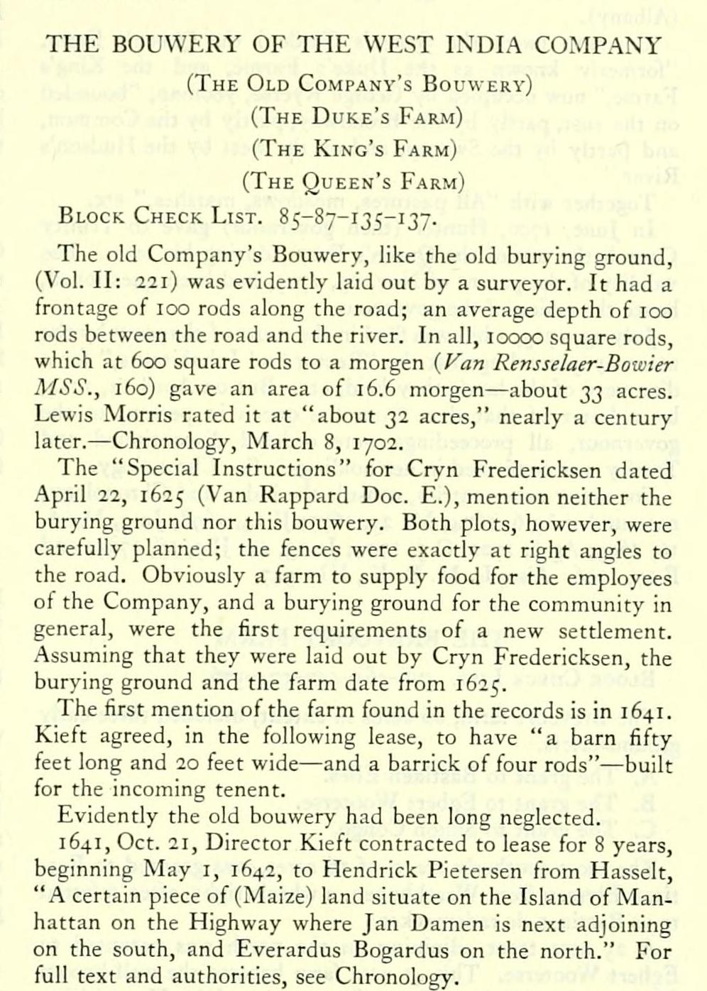
HE BOUWERY OF THE WEST INDIA COMPANY
(The Old Company's Bouwerv)
(The Duke's Farm)
(The King's Farm)
(The Queen's Farm)
Block Check List. 85-87-135-137.
The old Company's Bouwerv, like the old burying ground, (Vol. II: 221) was evidently laid out by a surveyor. It had a frontage of 100 rods along the road; an average depth of 100 rods between the road and the river. In all, loooo square rods, which at 600 square rods to a morgen {yan Rensselaer-Bowier MSS., 160) gave an area of 16.6 morgen — about 23 acres. Lewis Morris rated it at "about 32 acres," nearly a century later. — Chronology, March 8, 1702.
The "Special Instructions" for Cryn Fredericksen dated April 22, 1625 (Van Rappard Doc. E.), mention neither the burying ground nor this bouwery. Both plots, however, were carefully planned; the fences were exactly at right angles to the road. Obviously a farm to supply food for the employees of the Company, and a burying ground for the community in general, were the first requirements of a new settlement. Assuming that they were laid out by Cryn Fredericksen, the burying ground and the farm date from 1625.
The first mention of the farm found in the records is in 1641. Kieft agreed, in the following lease, to have "a barn fifty feet long and 20 feet wide — and a barrick of four rods" — built for the incoming tenent.
Evidently the old bouwery had been long neglected.
1641, Oct. 21, Director Kieft contracted to lease for 8 years, beginning May I, 1642, to Hendrick Pietersen from Hasselt, "A certain piece of (Maize) land situate on the Island of Manhattan on the Highway where Jan Damen is next adjoining on the south, and Everardus Bogardus on the north." For full text and authorities, see Chronology.
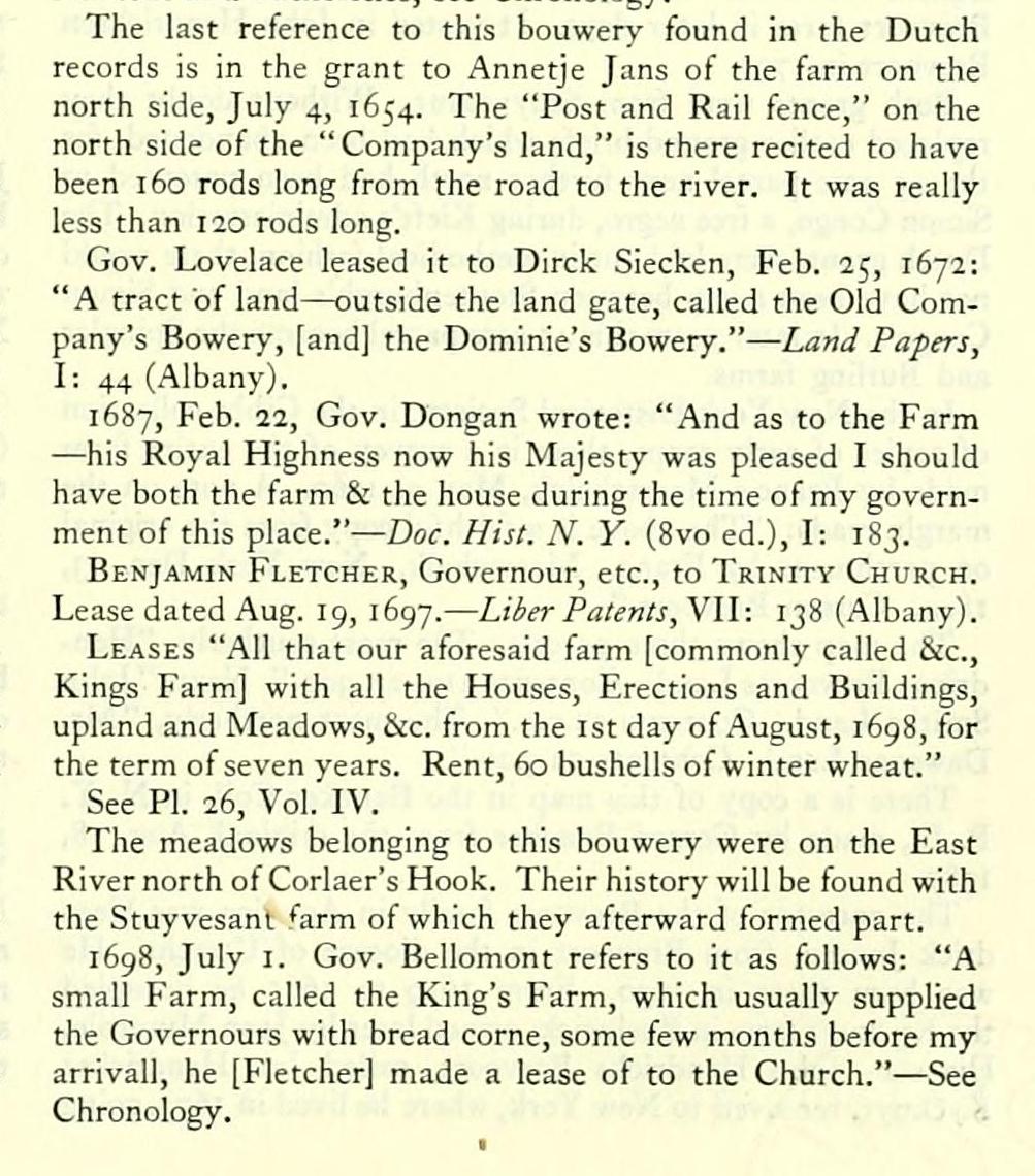
The last reference to this bouwery found in the Dutch records is in the grant to Annetje Jans of the farm on the north side, July 4, 1654. The "Post and Rail fence," on the north side of the "Company's land," is there recited to have been 160 rods long from the road to the river. It was really less than 120 rods long.
Gov. Lovelace leased it to Dirck Siecken, Feb. 25, 1672: "A tract of land — outside the land gate, called the Old Company's Bowery, [and] the Dominie's Bowery." — Land Papers, I: 44 (Albany).
1687, Feb. 22, Gov. Dongan wrote: "And as to the Farm — his Royal Highness now his Majesty was pleased I should have both the farm & the house during the time of my government of this place." — Doc. Hist. N. Y. (8vo ed.), I: 183.
Benjamin Fletcher, Governour, etc., to Trinity Church. Lease dated Aug. 19, 1697. — Liher Patents, VII: 138 (Albany).
Leases "All that our aforesaid farm [commonly called See, Kings Farm] with all the Houses, Erections and Buildings, upland and Meadows, &c. from the 1st day of August, i6g8, for the term of seven years. Rent, 60 bushells of winter wheat."
See PL 26, Vol. IV.
The meadows belonging to this bouwery were on the East River north ot Corlaer's Hook. Their history will be found with the Stuy vesanl farm of which they afterward formed part.
1698, July I. Gov. Bellomont refers to it as follows: "A small Farm, called the King's Farm, which usually supplied the Governours with bread corne, some few months before my arrivall, he [Fletcher] made a lease of to the Church." — See Chronology.
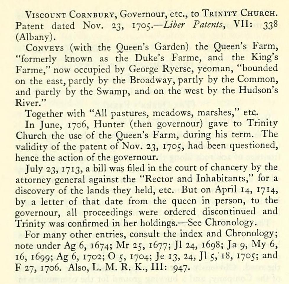
Viscount Cornbury, Governour, etc., to Trinity Church. Patent dated Nov. 23, i-jo^.— Liber Patents, VII: 338 (Albany).
Conveys (with the Queen's Garden) the Queen's Farm, "formerly known as the Duke's Farme, and the King's Farme," now occupied by George Ryerse, yeoman, "bounded on the east, partly by the Broadway, partly by the Common, and partly by the Swamp, and on the west by the Hudson's River."
Together with "All pastures, meadows, marshes," etc.
In June, 1706, Hunter (then governour) gave to Trinity Church the use of the Queen's Farm, during his term. The validity of the patent of Nov. 23, 1705, had been questioned, hence the action of the governour.
July 23, 1713, a bill was filed in the court of chancery by the attorney general against the "Rector and Inhabitants," for a discovery of the lands they held, etc. But on April 14, 1714, by a letter of that date from the queen in person, to the governour, all proceedings were ordered discontinued and Trinity was confirmed in her holdings. — See Chronology.
For many other entries, consult the index and Chronology; note under Ag 6, 1674; Mr 25, 1677; Jl 24, 1698; Ja 9, My 6, 16, 1699; Ag 6, 1702; O <, 1704; Je 13, 24, Jl 5, 18, 1705; and F 27, 1706. Also, L. M.'R. K., Ill: 947.
(The Old Company's Bouwerv)
(The Duke's Farm)
(The King's Farm)
(The Queen's Farm)
Block Check List. 85-87-135-137.
The old Company's Bouwerv, like the old burying ground, (Vol. II: 221) was evidently laid out by a surveyor. It had a frontage of 100 rods along the road; an average depth of 100 rods between the road and the river. In all, loooo square rods, which at 600 square rods to a morgen {yan Rensselaer-Bowier MSS., 160) gave an area of 16.6 morgen — about 23 acres. Lewis Morris rated it at "about 32 acres," nearly a century later. — Chronology, March 8, 1702.
The "Special Instructions" for Cryn Fredericksen dated April 22, 1625 (Van Rappard Doc. E.), mention neither the burying ground nor this bouwery. Both plots, however, were carefully planned; the fences were exactly at right angles to the road. Obviously a farm to supply food for the employees of the Company, and a burying ground for the community in general, were the first requirements of a new settlement. Assuming that they were laid out by Cryn Fredericksen, the burying ground and the farm date from 1625.
The first mention of the farm found in the records is in 1641. Kieft agreed, in the following lease, to have "a barn fifty feet long and 20 feet wide — and a barrick of four rods" — built for the incoming tenent.
Evidently the old bouwery had been long neglected.
1641, Oct. 21, Director Kieft contracted to lease for 8 years, beginning May I, 1642, to Hendrick Pietersen from Hasselt, "A certain piece of (Maize) land situate on the Island of Manhattan on the Highway where Jan Damen is next adjoining on the south, and Everardus Bogardus on the north." For full text and authorities, see Chronology.
The last reference to this bouwery found in the Dutch records is in the grant to Annetje Jans of the farm on the north side, July 4, 1654. The "Post and Rail fence," on the north side of the "Company's land," is there recited to have been 160 rods long from the road to the river. It was really less than 120 rods long.
Gov. Lovelace leased it to Dirck Siecken, Feb. 25, 1672: "A tract of land — outside the land gate, called the Old Company's Bowery, [and] the Dominie's Bowery." — Land Papers, I: 44 (Albany).
1687, Feb. 22, Gov. Dongan wrote: "And as to the Farm — his Royal Highness now his Majesty was pleased I should have both the farm & the house during the time of my government of this place." — Doc. Hist. N. Y. (8vo ed.), I: 183.
Benjamin Fletcher, Governour, etc., to Trinity Church. Lease dated Aug. 19, 1697. — Liher Patents, VII: 138 (Albany).
Leases "All that our aforesaid farm [commonly called See, Kings Farm] with all the Houses, Erections and Buildings, upland and Meadows, &c. from the 1st day of August, i6g8, for the term of seven years. Rent, 60 bushells of winter wheat."
See PL 26, Vol. IV.
The meadows belonging to this bouwery were on the East River north ot Corlaer's Hook. Their history will be found with the Stuy vesanl farm of which they afterward formed part.
1698, July I. Gov. Bellomont refers to it as follows: "A small Farm, called the King's Farm, which usually supplied the Governours with bread corne, some few months before my arrivall, he [Fletcher] made a lease of to the Church." — See Chronology.
Viscount Cornbury, Governour, etc., to Trinity Church. Patent dated Nov. 23, i-jo^.— Liber Patents, VII: 338 (Albany).
Conveys (with the Queen's Garden) the Queen's Farm, "formerly known as the Duke's Farme, and the King's Farme," now occupied by George Ryerse, yeoman, "bounded on the east, partly by the Broadway, partly by the Common, and partly by the Swamp, and on the west by the Hudson's River."
Together with "All pastures, meadows, marshes," etc.
In June, 1706, Hunter (then governour) gave to Trinity Church the use of the Queen's Farm, during his term. The validity of the patent of Nov. 23, 1705, had been questioned, hence the action of the governour.
July 23, 1713, a bill was filed in the court of chancery by the attorney general against the "Rector and Inhabitants," for a discovery of the lands they held, etc. But on April 14, 1714, by a letter of that date from the queen in person, to the governour, all proceedings were ordered discontinued and Trinity was confirmed in her holdings. — See Chronology.
For many other entries, consult the index and Chronology; note under Ag 6, 1674; Mr 25, 1677; Jl 24, 1698; Ja 9, My 6, 16, 1699; Ag 6, 1702; O <, 1704; Je 13, 24, Jl 5, 18, 1705; and F 27, 1706. Also, L. M.'R. K., Ill: 947.