Lot
Anthony Mathys - 1655-12-31
Lot Group
Original Grants and Farms
Original Grants and Farms Document(s)
Grant Lot Document(s)
Date Start
1655-12-31
Tax Lot Events
To Party 1
To Party 1 (text)
Anthony Mathys
From Party
From Party (Text)
Stuyvesant
Full Stokes Entry (See images below)
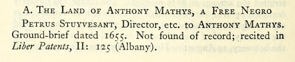
A. The Land of Anthony Mathys, a Free Negro Petrus Stuyvesant, Director, etc. to Anthony Mathys.
Ground-brief dated 1655. Not found of record; recited in
Liber Patents, II: 125 (Albany).
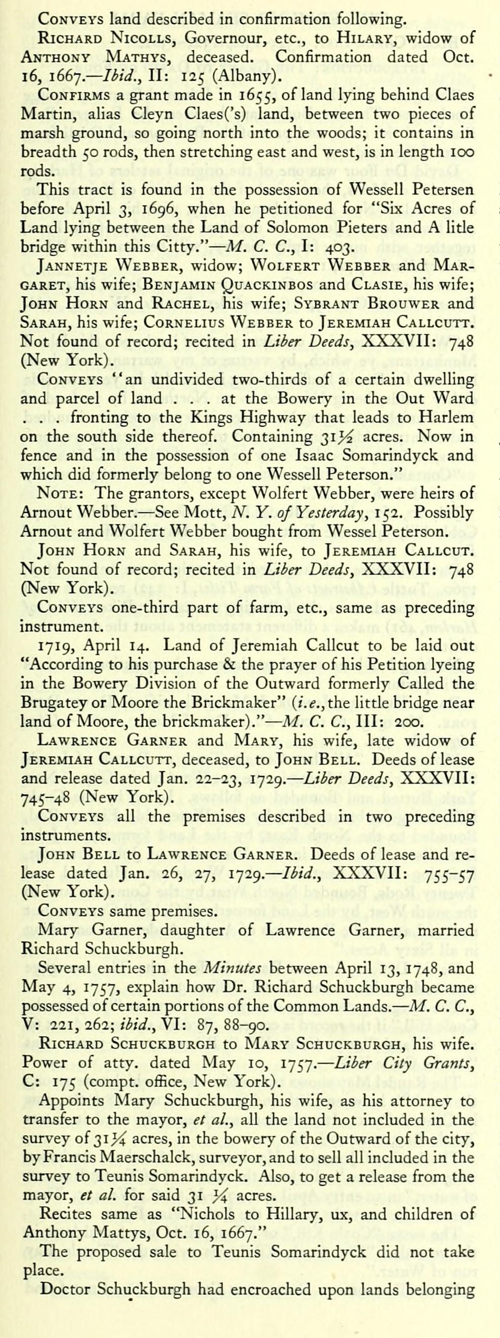
Conveys land described in confirmation following.
Richard Nicolls, Governour, etc., to Hilary, widow of Anthony Mathys, deceased. Confirmation dated Oct. 16, 1667— Hi J., II: 125 (Albany).
Confirms a grant made in 1655, of land lying behind Claes Martin, alias Cleyn Claes('s) land, between two pieces of marsh ground, so going north into the woods; it contains in breadth 50 rods, then stretching east and west, is in length 100 rods.
This tract is found in the possession of Wessell Petersen before April 3, 1696, when he petitioned for "Six Acres of Land lying between the Land of Solomon Pieters and A litle bridge within this Citty." — M. C. C, I: 403.
Jannetje Webber, widow; Wolfert Webber and Margaret, his wife; Benjamin Quackinbos and Clasie, his wife; John Horn and Rachel, his wife; Sybrant Brouwer and Sarah, his wife; Cornelius Webber to Jeremiah Callcutt. Not found of record; recited in Liier Deeds, XXXVII: 748 (New York).
Conveys "an undivided two-thirds of a certain dwelling and parcel of land ... at the Bowery in the Out Ward . . . fronting to the Kings Highway that leads to Harlem on the south side thereof. Containing 31^^ acres. Now in fence and in the possession of one Isaac Somarindyck and which did formerly belong to one Wessell Peterson."
Note: The grantors, except Wolfert Webber, were heirs of Arnout Webber. — See Mott, N. Y. 0/ Yesterday, 152. Possibly Arnout and Wolfert Webber bought from Wessel Peterson.
John Horn and Sarah, his wife, to Jeremiah Callcut. Not found of record; recited in Liier Deeds, XXXVII: 748 (New York).
Conveys one-third part of farm, etc., same as preceding instrument.
1719, April 14. Land of Jeremiah Callcut to be laid out "According to his purchase & the prayer of his Petition lyeing in the Bowery Division of the Outward formerly Called the Brugatey or Moore the Brickmaker" (i.e.,the little bridge near land of Moore, the brickmaker)." — M. C. C, III: 200.
Lawrence Garner and Mary, his wife, late widow of Jeremiah Callcutt, deceased, to John Bell. Deeds of lease and release dated Jan. 22-23, '7^9- — Liier Deeds, XXXVII: 745-48 (New York).
Conveys all the premises described in two preceding instruments.
John Bell to Lawrence Garner. Deeds of lease and release dated Jan. 26, 27, 1729. — Hid., XXXVII: 755-57 (New York).
Conveys same premises.
Mary Garner, daughter of Lawrence Garner, married Richard Schuckburgh.
Several entries in the Minutes between April 13, 1748, and May 4, 1757, explain how Dr. Richard Schuckburgh became possessed of certain portions of the Common Lands. — M. C. C, V: 221, 262; Hid., VI: 87, 88-90.
Richard Schuckburgh to Mary Schuckburgh, his wife. Power of atty. dated May 10, 1757. — Liier City Grants, C: 175 (corapt. office. New York).
Appoints Mary Schuckburgh, his wife, as his attorney to transfer to the mayor, et al., all the land not included in the survey of 31^^ acres, in the bowery of the Outward of the city, by Francis Maerschalck, surveyor, and to sell all included in the survey to Teunis Somarindyck. Also, to get a release from the mayor, et al. for said 31 yi acres.
Recites same as "Nichols to Hillary, ux, and children of Anthony Mattys, Oct. 16, 1667."
The proposed sale to Teunis Somarindyck did not take place.
Doctor Schuckburgh had encroached upon lands belonging
to the city. The following deed is in the nature of a release to the corporation of all the land outside the bounds of this carefully surveyed tract.
Richard Schuckburgh and Mary, his wife, to Mayor, el al. Deed dated May 11, 1757. — Liber City Grants, C: 177, compt. office (New York).
Conveys "all the Land contiguous to, but not included in the following boundaries:
"Beginning at a heap of stones at the S.E. corner of the following lot, where same joins the public Highway, which heap of stones is E. 13 ch. and 25 1. distant from [measured along] the three first courses hereafter mentioned, from a small run of water issuing out of said tract near S. W. corner into highway;
thence S. 66° 45', W. 7 ch.;
thence S. 73°, W. 3 ch., 30 1.;
thence S. 82°, W. 3 ch., 70 1.;
thence N. 17°, W. 19 ch.;
thence N. 3°, E. 3 ch., 8 1.;
thence N. 39°, E. 6 ch., 37 I.;
thence N. 73° 30', E. 5 ch., 60 1.;
thence S. 22°, E. 25 ch., 38 1. to Beginning. Containing 2i}i acres.
"Recites same as Nicolls to Hillary, the ux and children of Anthony Mattys, Oct. 16, 1667."
Richard Shucksburgh and Mary, his wife, to Benjamin NicoLL. Deed dated before July 15, 1759. Not found of record; recited in ibid., D: 108, compt. office (New York).
Conveys same land.
Mayor, Aldermen and Commonalty to John Watts, and William Nicoll, executors of Benjamin Nicoll, deed. Deed dated Dec. 17, 1770. — Ibid., D: 108, compt. office (New York).
Conveys same as preceding instrument.
Recites that the mayor, et al., on July 15, 1759, did agree to grant and release unto Benjamin Nicoll 3 or 4 acres adjoining on west side of said tract; and between the same and the road leading to Bloomingdale and opposite to farms of Adam Vanden Burgh and John De Witt, "and in order to straighten the highways . . . and further to accommodate Benjamin Nicoll, he the said Benjamin Nicoll did consent and agree to give up for the Publick use another small peice of ground from the S. W. angle of his farm, in a square as the fence now stands."
Samuel Nicoll, "Practitioner in Physick, Henry Nicoll and Alicie, ux, and Mathias Nicoll and Sarah, ux, of the first part to Casper Samlar, of the Outward, of the second part." Deed dated March 27, 1780. — Liber Deeds, XXI: 58 (Albany). Also recorded in Liber Deeds, CCCXLVIII: 595 (New York).
Conveys "All that certain farm or plantation tract, piece or parcel of land and messuage, tenement or dwelling-house, situate, lying and being at the three mile stone in the Out Ward of the City of New York between the publick Road leading from the said City tor'ds Kingsbridge and the publick Road that leads to Bloomingdale as the same is now in fence and in the Tenure and Occupation of the said Henry Nicoll, being Bounded on the S. partly by the said Road leading to Kingsbridge and partly by a piece of Commons; on the N. by land belonging to one Daniel Amos and on the E. .by other part of the said Commons which said Farm and plantation contains about 37 Acres of land more or less, together with all and singular the barns, etc."
Ground-brief dated 1655. Not found of record; recited in
Liber Patents, II: 125 (Albany).
Conveys land described in confirmation following.
Richard Nicolls, Governour, etc., to Hilary, widow of Anthony Mathys, deceased. Confirmation dated Oct. 16, 1667— Hi J., II: 125 (Albany).
Confirms a grant made in 1655, of land lying behind Claes Martin, alias Cleyn Claes('s) land, between two pieces of marsh ground, so going north into the woods; it contains in breadth 50 rods, then stretching east and west, is in length 100 rods.
This tract is found in the possession of Wessell Petersen before April 3, 1696, when he petitioned for "Six Acres of Land lying between the Land of Solomon Pieters and A litle bridge within this Citty." — M. C. C, I: 403.
Jannetje Webber, widow; Wolfert Webber and Margaret, his wife; Benjamin Quackinbos and Clasie, his wife; John Horn and Rachel, his wife; Sybrant Brouwer and Sarah, his wife; Cornelius Webber to Jeremiah Callcutt. Not found of record; recited in Liier Deeds, XXXVII: 748 (New York).
Conveys "an undivided two-thirds of a certain dwelling and parcel of land ... at the Bowery in the Out Ward . . . fronting to the Kings Highway that leads to Harlem on the south side thereof. Containing 31^^ acres. Now in fence and in the possession of one Isaac Somarindyck and which did formerly belong to one Wessell Peterson."
Note: The grantors, except Wolfert Webber, were heirs of Arnout Webber. — See Mott, N. Y. 0/ Yesterday, 152. Possibly Arnout and Wolfert Webber bought from Wessel Peterson.
John Horn and Sarah, his wife, to Jeremiah Callcut. Not found of record; recited in Liier Deeds, XXXVII: 748 (New York).
Conveys one-third part of farm, etc., same as preceding instrument.
1719, April 14. Land of Jeremiah Callcut to be laid out "According to his purchase & the prayer of his Petition lyeing in the Bowery Division of the Outward formerly Called the Brugatey or Moore the Brickmaker" (i.e.,the little bridge near land of Moore, the brickmaker)." — M. C. C, III: 200.
Lawrence Garner and Mary, his wife, late widow of Jeremiah Callcutt, deceased, to John Bell. Deeds of lease and release dated Jan. 22-23, '7^9- — Liier Deeds, XXXVII: 745-48 (New York).
Conveys all the premises described in two preceding instruments.
John Bell to Lawrence Garner. Deeds of lease and release dated Jan. 26, 27, 1729. — Hid., XXXVII: 755-57 (New York).
Conveys same premises.
Mary Garner, daughter of Lawrence Garner, married Richard Schuckburgh.
Several entries in the Minutes between April 13, 1748, and May 4, 1757, explain how Dr. Richard Schuckburgh became possessed of certain portions of the Common Lands. — M. C. C, V: 221, 262; Hid., VI: 87, 88-90.
Richard Schuckburgh to Mary Schuckburgh, his wife. Power of atty. dated May 10, 1757. — Liier City Grants, C: 175 (corapt. office. New York).
Appoints Mary Schuckburgh, his wife, as his attorney to transfer to the mayor, et al., all the land not included in the survey of 31^^ acres, in the bowery of the Outward of the city, by Francis Maerschalck, surveyor, and to sell all included in the survey to Teunis Somarindyck. Also, to get a release from the mayor, et al. for said 31 yi acres.
Recites same as "Nichols to Hillary, ux, and children of Anthony Mattys, Oct. 16, 1667."
The proposed sale to Teunis Somarindyck did not take place.
Doctor Schuckburgh had encroached upon lands belonging
to the city. The following deed is in the nature of a release to the corporation of all the land outside the bounds of this carefully surveyed tract.
Richard Schuckburgh and Mary, his wife, to Mayor, el al. Deed dated May 11, 1757. — Liber City Grants, C: 177, compt. office (New York).
Conveys "all the Land contiguous to, but not included in the following boundaries:
"Beginning at a heap of stones at the S.E. corner of the following lot, where same joins the public Highway, which heap of stones is E. 13 ch. and 25 1. distant from [measured along] the three first courses hereafter mentioned, from a small run of water issuing out of said tract near S. W. corner into highway;
thence S. 66° 45', W. 7 ch.;
thence S. 73°, W. 3 ch., 30 1.;
thence S. 82°, W. 3 ch., 70 1.;
thence N. 17°, W. 19 ch.;
thence N. 3°, E. 3 ch., 8 1.;
thence N. 39°, E. 6 ch., 37 I.;
thence N. 73° 30', E. 5 ch., 60 1.;
thence S. 22°, E. 25 ch., 38 1. to Beginning. Containing 2i}i acres.
"Recites same as Nicolls to Hillary, the ux and children of Anthony Mattys, Oct. 16, 1667."
Richard Shucksburgh and Mary, his wife, to Benjamin NicoLL. Deed dated before July 15, 1759. Not found of record; recited in ibid., D: 108, compt. office (New York).
Conveys same land.
Mayor, Aldermen and Commonalty to John Watts, and William Nicoll, executors of Benjamin Nicoll, deed. Deed dated Dec. 17, 1770. — Ibid., D: 108, compt. office (New York).
Conveys same as preceding instrument.
Recites that the mayor, et al., on July 15, 1759, did agree to grant and release unto Benjamin Nicoll 3 or 4 acres adjoining on west side of said tract; and between the same and the road leading to Bloomingdale and opposite to farms of Adam Vanden Burgh and John De Witt, "and in order to straighten the highways . . . and further to accommodate Benjamin Nicoll, he the said Benjamin Nicoll did consent and agree to give up for the Publick use another small peice of ground from the S. W. angle of his farm, in a square as the fence now stands."
Samuel Nicoll, "Practitioner in Physick, Henry Nicoll and Alicie, ux, and Mathias Nicoll and Sarah, ux, of the first part to Casper Samlar, of the Outward, of the second part." Deed dated March 27, 1780. — Liber Deeds, XXI: 58 (Albany). Also recorded in Liber Deeds, CCCXLVIII: 595 (New York).
Conveys "All that certain farm or plantation tract, piece or parcel of land and messuage, tenement or dwelling-house, situate, lying and being at the three mile stone in the Out Ward of the City of New York between the publick Road leading from the said City tor'ds Kingsbridge and the publick Road that leads to Bloomingdale as the same is now in fence and in the Tenure and Occupation of the said Henry Nicoll, being Bounded on the S. partly by the said Road leading to Kingsbridge and partly by a piece of Commons; on the N. by land belonging to one Daniel Amos and on the E. .by other part of the said Commons which said Farm and plantation contains about 37 Acres of land more or less, together with all and singular the barns, etc."

Lot Event Type