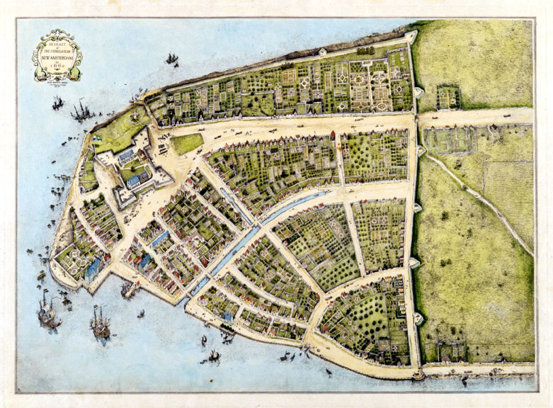
User account menu

Show — User account menu Hide — User account menu
  • Log in
  • Register

logo2logo2

header2

Mapping Early New York | Encyclopedia

Where we explore the early history of New Amsterdam and New York City, its diverse people, landscapes, institutions and global legacy today.

3D Model
Map
About
Mapping Early New York is made possible by support from the Society of Daughters of Holland Dames, the First Families of New York, the Ken Chase Foundation, and the Robert David Lion Gardiner Foundation.


Support Us

Document: Map_Castello Plan_Redrawn in 1913

Search All Content
Open Timeline
Document Date Notes
1660
Image
Map_Castello Plan_Redrawn in 1913
Document Location
Document Finding Aid or Collection
Maps

SEARCH CONTENT

Sidebar Menu

Show — Sidebar Menu Hide — Sidebar Menu
  • HOME
  • CONTENT LIST
  • Tax Lots
  • Grant Lots
  • Original Grants and Farms
  • Ancestors - Male
  • Ancestors - Female
  • Marriages
  • Occupations
  • Surnames
  • Document Collections
  • Document Types
  • Documents
  • Ships
  • Ship Journeys
  • Places
  • Objects
  • Object Types
  • Tax Lot Events
  • Tax Lot Event Types
  • Property Types
  • Entities
  • Entity Roles
  • Curricula

Mapping Early New York is made possible by support from the Society of Daughters of Holland Dames, the First Families of New York, the Ken Chase Foundation, and the Robert David Lion Gardiner Foundation.


Support Us